+2 0122-345-3028
This email address is being protected from spambots. You need JavaScript enabled to view it.

Super User
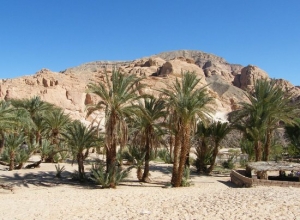
Oyun Musa

Oyun Musa
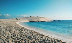
Oyun Musa or “Springs of Moses” is located about 16 miles south of the Ahmed Hamdi Tunnel, which connects the mainland Egypt with Sinai. It is believed that this is the Springs of Moses.
Moses is said to have, upon the advice of God, thrown a special tree into the brackish water which made it drinkable. Today the spring is still brackish, and there is no tree in sight, but seven of the original 12 springs still exist.
During the Egypt Expedition we know that there were nine springs still active. At one point during the 19th century, this, the largest of the Sinai Oases, became a popular retreat for foreign diplomats.
There is a small community that has grown up around the springs
Naama Bay
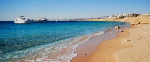
Naama Bay
The City Centre of Sharm El Sheikh, either escape the routine and take a walk through Naama Bay, it consider the heart of event at Sharm, this street never sleep at day, even at night, it provides plenty of Hotels, resorts, restaurants and bars to make your holiday in sharm ravishing.
The most wonderful tourist attractive lies at Naama Bay, treat yourself to pampered with the crystal pure water at Naama Bay, experience shopping there, try amazing night full of dance, walking and taste the real mean of happiness, for nightclubs lover, Naama Bay offering international clubs such as Pacha, little Buddha and Hard Rock as well.
Explore plenty of diving centers, luxurious hotels and resorts. At Naama Bay, you can try all items of beach and water activities including glass-boat rides, kayaking, parasailing, wind surfing, banana boat rides and of course, most importantly, swimming and sunbathing, In addition with Excursions to Sharm El Sheikh you can experience a plenty of tours from Naama Bay which including snorkeling trip to Ras Mohammed national park.
Mount Sinai
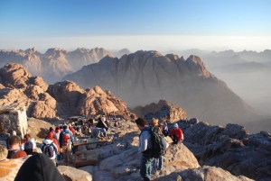
Mount Sinai
Mount Sinai
(Jebel Musa, or Mount Moses)
John Lloyd Stephens said that "Among all the stupendous works of Nature, not a place can be selected more fitting for the exhibition of Almighty power.
Mount Sinai is both the name of a collection of peaks, sometimes referred to as the Holy Mountains, and the biblical name of the peek on which Moses received the Ten Commandments.
Mount Mousa (or Musa), also referred to as Jebel Musa, Gebel Mousa, Mount Moses or the Mountain of Moses (all of which basically means the same thing) is considered to be that biblical peak.
This peak has religious significance: It is venerated by Christians, Jews and Muslims as the site of the God’s revelation of the Ten Commandments, and in Islam as the place where Mohammed's horse, Boraq, ascended to heaven. The visitors are keen on climbing the mountain to watch sunrise.
The 7,497 foot mountain has 3,750 steps hewn out of stone by monks of St. Catherine's Monastery, which is located just to the North.
The peak is accessible by the steps, or by a gentler path east of the monastery. Both lead to an amphitheater known as the "Seven Elders of Israel". From there, one must ascend the remaining 750 steps to reach the summit where the Chapel of the Holy Trinity was built in 1934 (on the location of the original chapel built in 363 and rebuilt by Justinian in 530) and affords a truly breathtaking view.
It is recommended that you take the steps down, as they will lead you past the fountain of Moses, a small chapel of the Virgin, and two arches, the Gate of St. Stephen and the Gate of the Law.
There are other peaks in this range, some of which have also been contested as the true Mount Sinai. Jebel Serbal is also a candidate. Other peaks in this range include Jebel Megafa and Jebel Moneiga.
Geziret Faraoun
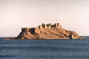
Geziret Faraoun
Geziret Faraoun
There are a number of forts in Egypt. The most famous of these is the Citadel in Cairo, but also notable is Fort Qaitbey in Alexandria, built on the location of the legendary Pharos Lighthouse. Probably the least known of the major forts is located on Pharaoh's Island in the Gulf of Aqba.
This fortress would undoubtedly draw much larger crowds of tourists were it located in a more mainstream tourist destination, but tourists who make an effort to visit the fort will usually have the island mostly to themselves.
Pharaoh's Island, sometimes called Coral Island, or Geziret Faraoun, is the location of a Crusader fortress originally built by Baldwin I, the King of Jerusalem. From the top of the fortress, one can see four countries, including Egypt, Israel, Jordan and Saudi Arabia. Work apparently began on the fortress around 1116 AD. Baldwin built the Fortress for three reasons: First it was in the center of a huge trade route between the Far East and Europe, second it was easily defendable, being out of range of land based catapults and was on high ground and third it was in the narrowest section of the Gulf of Aqaba.
At various times while in Crusader hands, it was used to collect taxes on Arab merchants, and sometimes to attack Arab shipping, while at the same time protecting pilgrims traveling between Jerusalem and St. Catherine's Monastery.
The fortification was, however, captured by Salah ad-Din in about 1170. He expanded the fortress considerably and that it was possibly not abandoned until the 13th century and the Mamelukes and Ottomans probably further enhanced it.
The fortress, which is completely renovated, has many small rooms some with arched doorways and other without. These rooms included sleeping quarters for the troops, bath houses and kitchens with huge ovens. There are towers to house carrier pigeons, which were used for relaying messages in the middle Ages and circular towers for archers. Little else of the Fortress history is known. Obviously at least one important battle took place there, when Salah ad-Din took the Fortress from the Crusaders, but beyond that we really here of no major battles involving the fort.
Colored Canyon
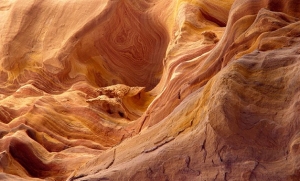
Colored Canyon
It lies between St. Catherine's Monastery and the town of Nuweiba. It is a natural formation of sandstone and limestone of various colours worn away over the centuries by rains draining from the mountain top.
Exquisite patterns have been formed of a myriad colour forming patterns of all shapes and sizes. Some resemble wood grain – others surrealism paintings – but these are note man made. Different shapes and colours greet you upon every turn.
It has become a popular safari trek and the strange rock formations and the rainbow- hued colored canyon walls are dramatic and the silence within -only adds to the oddity. Great for walking or rock-climbing
Ain Hudra Oasis
Ain Hudra Oasis
One of the loveliest Oasis in Sinai. Nature has carved the sandstone to fascinating shapes.
The yellow and brown of the desert canyon give way to green when reaching the Ain Hudra Oasis.
Here we can explore the big palm trees forest and the gardens of olives, grapes and orange close to the spring of water.
Bedouins have their little houses on the slopes leading up the mountain sides.
Tanis (San el – Hagar)
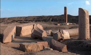
Tanis (San el – Hagar)
As one approaches the little village of San el-Hagar in the north eastern delta one can see from afar the huge hills of the ruins of Tanis, called Zoan in the Bible. It was the largest settlement mound of antiquity in Egypt (Known as a "kom", an earthen mound over ancient buildings), measuring 5200 X 3900 feet (1600 X 1200 m), and reaching a height of just under 130 feet (40 m). It soon attracted the attention of excavators. Auguste Mariette went to Tanis in 1860, Flinders Petrie followed in 1883/84 and in 1929-1951 the French archaeologist Pierre Montet, who was to succeed in uncovering the tombs of the kings, dug there. A French team is working in Tanis today and no end to their work is in sight. The place was elevated to be the new capital of Egypt at the start of the Twenty-first Dynasty, when the Ramesside capital in piramesse was abandoned for both political and economic reasons. In the center of the hill lies the great temple of Amun. It is enclosed by a massive brick wall, 1397 X 1200 feet
(430 X 370 metres), which was last extended under the ptolemies.
The entrance has a huge gate built by Shoshenq III (Twenty-second Dynasty) and like so many buildings in Tanis it consists of older blocks of granite that were dragged here and fitted together. Behind this, stretches an area full of monuments, statues, obelisks, columns and relief blocks, but the original architecture is almost totally lost.
The Temple Area
21st /22nd Dynasty, 10th /9th centuries B.C.
When the Tanite rulers took the decision to move their capital further to the north, into the delta, a major problem had to be solved. For the stone quarries for the building material lay far away in Upper Egypt. Consequently, they ordered the buildings and monuments of the Ramesside metropolis to be demolished; these were then taken over a distance of a good 13 miles (20 km), to be re-erected at their new destination. It was a process that must have taken several decades. Even after the political power shifted to other delta cities in the course of the 1St millenium B.C. the tradition of settlement at Tanis persisted right into Greek and Roman times. The main shrine (ca. 760 feet or 235 m in length) was fitted out with particular elaboration; it had three great pylons before the rear temple building and consisted for the most part of blocks of granite. Four obelisks stood before the third pylon dedicated to Osorkon II alone (Twenty-second Dynasty), with colossal figures from the time of Ramesses the Great.
Colossal Figure of Ramesses II
The long reign of Ramesses II lasted 67 years, from 1279 to 1213 B.C. Among other things it meant that not enough of the statues of the ruler needed for his gigantic building program were available anywhere in the land. Hence numerous statues of earlier kinds were removed from shrines in the greater Memphis district as well as from Delta sites and used to adorn the temple buildings. They included original works of the Nineteenth Dynasty like this upper part of a colossal standing figure ( 12.5 feet or 3.85 m high ) .
Obelisk of Ramesses II
Although Tanis suffered for many years from the persistent removal of its stones and many individual monuments have found their way into the museums of Cairo and Paris , the great wealth of objects that are still in place do give some idea of the former magnificence of the temple . As well as countless statues, some of which are up to 65 feet (20 m) high, 23 obelisks alone have been discovered. Most of them, like this great fragment (13 feet or 4.20 m high) are of red granite and were once made for the "House of Ramesses" under Ramesses II.
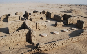
The Tombs of the Kings
Twenty- first / Twenty –second Dynasties,
10th / 9th century B.C.
In the south west corner of the temple complex the French archaeologist Pierre Montet found royal necropolis for kings of the Twenty-first and Twenty-second Dynasties in 1939. The burial chambers lie close together. They were once underground and no trace had remained of the superstructures that were assumed to have surmounted them. The tombs , and particularly the rich treasure in the tomb of Psusennes I (Twenty – first Dynasty) can certainly compare with the contents of the tomb of Tutanhamun , with cult vessels of precious stones , magnificent jewelry and not least the golden mask of the king . Psusennes I's consort Mutnodjmet, Pharaoh Amen- mope and his general Wendjebauendjed were all buried with Psusennes I . Beside this tomb is the burial chamber of Osorkon II, and slightly to one side the tomb of Shoshenq III. Two more burial chambers remained unfinished. The earth at Tanis may hide more sensations, for great kings of this period, like Shoshenq I, and their tombs have not yet been discovered.
The Silver Coffin of Psusennes
Twenty- first Dynasty, Ca. 1000 B.C., silver, gold,
L.185 cm, Egyptian Museum, Cairo
As wan the custom of the pharaohs of the New Kingdom, Psusennes I also ordered himself to be buried in several layers of coffin. But it was not easy to carry out his command, for the shortage of stone in the delta was an unwelcome but indisputable fact, even for royal tombs. The solution was pragmatic rather than appropriate to a pharaoh, for Psusennes used his contacts with the priest kings of the divine state of Amun to appropriate a granite sarcophagus of king Merenptah (Nineteenth Dynasty), whose tomb in the Valley of the kinds had already been plundered. The second anthropomorphic coffin of black granite was also given a new inscription. It had once held an official of the early Nineteenth Dynasty. It was in this that the magnificent silver coffin of the Tanite ruler was laid and it can be seen as an original artefact of his time. The changing play of the metal colors is extremely beautiful.
Pectoral of Psusennes I with heart scarab
Twenty-first Dynasty, ca. 1000 B.C., gold with inlays,
H. 10.5 cm, Egyptian Museum, Cairo
Montet found many items of jewelry on Psusennes I's mummy, including this magnificent pectoral in the form of a winged scarab (in dark green jasper). The scarab was a powerful symbol of regeneration and recurs on many of the items of jewelry in the tomb. Here it links a Shen ring, the sign of cyclical infinity, with a horizontal cartouche that contains the birth name of Psusennes I. Most of the Tanite gold is suspected to be recycled material from New Kingdom burials.
The Golden Mask of Psusennes I
Twenty- first Dynasty, ca. 1000 B.C., gold, lapis, lazuli
H.48 cm, Egyptian Museum, Cairo
Whereas only pure face masks were used in the other royal burials at Tanis, the golden mask of Psusennes I completely envelops the head of the deceased ruler, transmitting his features to us in timeless beauty. The king wears the headdress with a rearing uraeus on his forehead, the plaited beard of the divine ruler and a broad necklace adorned with a floral pattern. His eyebrows, eyelids and the plaited beard are inlaid with costly lapis lazuli.
Tell El-amarna
Tell El-Amarna
Tell El-Amarna was formally known as Akhenaton. The new name came from a local village called El- Till. The word Amarna came from the Bedouin tribe that settled in this village. The word Tell, in Arabic, means a mound or a small hill. But interestingly enough, Tel El-Amarna is a flat piece of land beside the Nile Valley. The ancient name, Akhetaten, means the horizon of the solar disk. It is very similar to the meaning of Amun Dwelt at Thebes, Ptah at Memphis and other gods at their favoured places. King Akhenaton offered this place to be the home for his god Aton. The area is a plain field, separated from the Nile Valley by a strip of palm trees. It stretches 12 kilometres from north to south. The area is covered mostly with sand and outlined with ruins of temples, palaces and houses that archaeologists discovered or are trying to find. Some tourists considered it one of the most romantic places they have ever seen because of the silence and the peaceful beauty that the area gained through the centuries.
The Tombs
There are more than twenty-five tombs facing the base of the cliff front. Six tombs are located at the north side near Darb El-Malik. Nineteen of them are located at the south side. If you are going to navigate through the tombs, we do recommend a tour guide to be with you for safety reasons. These tombs were built highly complicated to protect them from the thieves, therefore a visitor could get lost. Most of the tombs start with an open court that leads to three chambers. Some of the tombs are decorated with papyrus columns that meet at a recess in the rear end which have a statue of the deceased looking toward the entrance. The famous lyrics of the Hymn to the Sun, which was composed by Akhenaten, is always found in the decorations of each tomb. The following section describes the famous tombs located in Tel El-Amarna.
Ay's Tomb
This is considered to be the finest tomb remaining in the necropolis. The drawings show Ay and his wife receiving gold collars from Akhenaten and Nefertiti while the surrounding crowd seems cheerful by this honour. There are some descriptive scenes for the streets of ancient Akhetaten which are closely observed and described. Other drawings describe a few intimate moments in the palace of Ay; a woman of the harem having her hair done, other girls are playing the harp and dancing, while others clean the house and prepare the food. In the same temple, the most complete and correct version of the Hymn to the Sun is decorating the right hand side of the doorway.
Huya's Tomb
Huya, or Yuya, was the steward of Queen Tiyi, the queen mother and wife of Amenhotep III. A Royal banquet is located to the left and right of the main hall. The banquet contains drawings for the king, queen and their children. One of the walls has a drawing for the king accompanying his Queen Tiyi to the Sunshade temple that was erected for her.
Meri-re II
Meri-re II was the superintendent of the palace of Queen Nefertiti. A unique drawing on the right wall features a celebration to honour leaders from other countries that brought some exotic gifts to the Queen. The visitors are shown in their native dresses. Other drawings show the celebration and the Pharaoh's hospitality.
Meri-re I
He was a high rank priest of Aton. A table full of offerings including a beautiful representation of a colourful rainbow is drawn on the left hand wall of the main chamber below the Aton disk. On the right hand wall, a scene of the Aton Temple which shows a depiction of the Akhetaten harbor, the palaces and the gardens of the ancient city.
Panhesy
He was the chief servitor of the Aton in Akhetaten. The facade that decorated the outside of his tomb is still preserved. A group of Aton worshippers are featured on the top of the outer lintel of the entrance. The group of the featured Aton Disk worshipers includes the king's sister and two of her servants. In the corridor walls of the tomb, the deceased is featured as an elderly man sitting beside his daughter.
Beni Hassan al-Shurrug
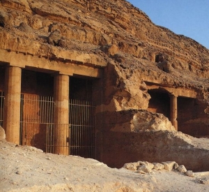
Beni Hassan al-Shurrug
Location:
20 km (12 MILES) South of Minya, Egypt
How to get there:
By private vehicles, taxis and tourist buses.
For information and reservation contacts us
Description
The site lies on the Eastern Bank of the Nile, 20 km south of the city of Al-Minya. It houses 39 rock-cut tomb decorated with scenes depicting local and regional life during the Middle Kingdom. Many of these have scenes of violent warfare and military training.
They include:
Tomb of Amenemhet (tomb 2):
Amenemhet is described as the 'prince of the Oryx Nome' and was a governor of the Oryx nome. Here one finds one of two inscriptions within the necropolis that help define Egyptian life in this period. It consists of thirty-two lines on the door. There are also unusual scenes depicting hunting in the desert on the north wall. His tomb is unusual for having a false door on the west, where the dead are suppose to enter.
Tomb of Khnumhotep (tomb 3):
A governor under Amenemhet III (about 1820 BC), Khnumhotep's is described as 'the hereditary lord' and his tomb is beautifully done with scenes of daily life. His biographical inscription within the tomb is 222 columns of text and help define Egyptian life during this period. There are also acrobats over the door.
Tome of Khnumhotep I (tomb 14)
Tome of Baqet III (tomb 15):
If ever there was an imaginative person, the father of Kheti (see below) was one. A strange tomb with scenes depicting a hunt for unicorns, a serpent-headed quadruped, a 'Sethian' animal and a griffin. Apparently, the Egyptians felt that there were evil forces in the desert, and hunting there helped to preserve order. Others show wrestlers and gazelles involved in strange behaviour.
Tomb of Kheti (tomb 17):
During the 11th Dynasty, Kheti was a governor of the Oryx nome. The tomb has depictions of daily life during the period.
About two miles south is the Temple of Hatshepsut in an area popularly called Istabl Antar (Stables of Antar).
Marsa Matrouh
Marsa Matrouh
Mersa Matrouh
Mersa Matrouh lies 290 km. west of Alexandria and 222 km. from Sallum. The distance from Cairo to Matrouh is 524 km. It lies on a bay on the Mediterranean and is distinguished by its seven km. long beach, which-as all visitors have testified-is one of the most beautiful in the world.
The beach is famous for its white soft sands and calm transparent waters, for the bay is protected from the high seas by a series of rocks forming a natural wave-breaker, with a small opening to allow light vessels in.
This beach dates back to the days of Alexander, the Macedonian, when it was known as "Paraetonium" and also as "Amunia". It said that Alexander the Great stopped there during his historical expedition to pay tribute, and sacrifice, to the god Amun, at Siwa, so that he becomes Amun's son and his rule is a historical continuation of the pharaohs. There are ruins of a temple from the time of Rameses II (1200 B.C.) in Matrouh.
Most important places / beaches for visit
Rommel's Hideout:
A cave, hewn in the rock, where Rommel drew up plans of his military operations. It has now been turned into a military museum.
Ageebah Beach:
About 28 km. west of Mersa Matrouh, it is distinguished by its numerous natural caves and enchanting scenery.
Al-Abyad Beach:
About 20 km. west of Mersa Matrouh beauty surpasses that of Mersa Matrouh beach