+2 0122-345-3028
This email address is being protected from spambots. You need JavaScript enabled to view it.

Super User
Farafra oasis
Farafra Oasis
Farafra, known as Ta-iht or the Land of the Cow in pharaonic times, is a single village. The most isolated of the New Valley Oases it is renowned for its strong traditions and piety. According to folklore, the villagers once lost track of time and had to send a rider to Dakhla so they could hold the Friday prayers on the right day. The oldest part of the village, on a hillside, is next to peaceful walled palm groves; a short ride away there are hot sulphur springs at Bir Setta and swimming at El-Mufid Lake.
Mostly inhabited by Bedouins, the small mud-brick houses all have wooden doorways with medieval peg locks. As in other oases, many of Farafra's houses are painted blue (to ward off the Evil Eye) but here some are also decorated with landscapes, birds and animals, the handiwork of local artist, Badr.
A combination house, museum and studio exhibiting his paintings and ceramics are situated in a garden full of sculptures made from objects found in the surrounding desert.
The only real village in the Farafra Oasis, Qasr Al Farafra is a quite and relaxing place, which represents most of what it has to offer tourists. There are few tourist accommodations in the area, but that may change in the near future. Most of the description of the Farafra Oasis applies to the town itself.
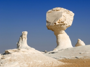
The White Desert, 20 km from Farafra on the Highway between Farafra and Bahariya, is one of the most exiting places. A surreal landscape of fungoid shapes that glint pale gold in the midday sun and turn pink and violet around dusk, resembling icebergs at dawn and snowdrifts by moonlight, the chalk outcrops loom over dusty ground littered with fossils, quartz crystals and iron pyrites shaped like sea-urchins or twigs. Herds of gazelles may be glimpsed at daybreak, when they forage for a couple of hours.
Of those with an interest in Egypt, and particularly the Western Oasis, the Farafra is probably one of the least known Oases. It is actually one of the most difficult Oasis to reach and offered the pharaohs, caliphs and kings very little, though it seems to be on the way to everywhere.
There is actually very little known of the Farafra Oasis prior to the Roman period, and even of that period only a few remains have been found. While the oasis offers a stunning desert landscape, there is little in the way of antiquities to see. According to a statue of the 5th Dynasty, Farafra, as well as the Bahariya Oasis were probably a part of the Egyptian empire during the Old Kingdom. It was known as the Trinitheos, Ta-ihw, and the Land of the Cow (in reference to Hathor).
It was often invaded whenever the Libyans decided to attack Egypt, being on their way to the Nile Valley. Though we have little idea what the reference refers to, the text known as the Eloquent Peasant refers to the "rods of Farafra" in relationship to produce, giving us at least a citation to the oasis during the First Intermediate Period.
During the New Kingdom there is somewhat more evidence that comes to us from the Farafra Oasis. A stela was discovered in the Oasis dating to the 18th Dynasty, but it provides little information. However, we find documentary records from the reign of Ramesses II in the Temple of Luxor that he received precious stones form Farafra that were used in some of his extensive building works along the Nile Valley. However, the references does not provide information on the type of stones, and no evidence of ancient mining activities has so far been unearthed in the oasis. What is known is that during the 19th Dynasty reign of Merenptah, Ramesses II's son and successor, the oasis was captured by Libyan invaders who used it as a base to attack the Nile Valley. As a side note, the Farafra Oasis is actually closer to Libya than to the Nile Valley.
During the Third Intermediate Period, though little supporting evidence is available, the Farafra may have been an important way station for both armies and trade caravans. We do know that there were several major caravan routes that operated through the Farafra during this period.
Though the quantity is small, the earliest antiquities currently found in the Farafra Oasis date from the Roman Period. During that time, it probably held some real importance for the Romans because it sat at the center of their African holdings, connecting the Nile Valley to the Libyan oasis such as Jalo and Kufra. So far, the Roman antiquity sites found in the Oasis are actually at Ain Della, now often called the "Hidden Valley", which is actually a separate depression just north of Farafra, with others found at Wadi Hinnis along the main caravan route to the Bahariya Oasis, and at Ain Besay just to the south of Qasr Farafra.
During the Roman Byzantine Period, the oasis mostly converted to Christianity and remained Christian far into the Islamic era, even though it was, the first Western Desert oasis conquered by the Arabs. Little evidence exists that it became a place of banishment like the Siwa and Kharga Oasis, but it is likely to have been, given its remote location. We do find a number of Coptic inscriptions in the oasis, as well as clearly Christian houses and cemeteries dating to the 10th century.
Actually, the Islamic religion did not enter the Farafra Oasis from the Nile Valley, but rather from North Africa. Our first reference of the oasis during the early Islamic period is the Kitab al-buldan by al-Yaqubi written during the 9th century. It says of the Farafra that the oasis was inhabited by people of "all descents". This document was written at about the time that the oasis began to be converted to the Islamic faith.
The Arab rulers of Egypt maintained a relatively large army in the desert. Unfortunately, this was a difficult period for many people in the Western Oasis, and like elsewhere, the Farafra was almost depopulated by the Mamluk rule of Egypt.
Today, Farafra has not just entered the new world, though its essence remains elusive and mysterious, the oasis is scheduled to add new chapters to world history. As a part of the visionary New Valley Project, soon Farafra will change forever. With many incentives for Egyptian families to move to the New Valley in order to elevate overcrowding in current urban centers, there are many more villages in or near the Oasis, and each is provided with a school, a hospital and a mosque. Industry is also arriving in the oasis in the form of Fiber optics
The Farafra is also being developed for tourism, and while there are few ancient artifacts in the region, the desert is wonderfully diverse.
Dakhla Oasis
Dakhla Oasis
The Dakhla Oasis lies to the northwest of Kharga and is also about 310 km to the southeast of Farafra. This oasis consists of 14 settlements and has a population of about 70,000 people. Dakhla is the farthest oasis out of Cairo and is considered one of Egypt's most beautiful Oases.
Dakhla sits in a depression surrounded by pink cliffs. There are about 30,000 acres of cultivated land. Most of its 70,000 or so residents are farmers who constantly fight the battle of the dunes that threaten their fields and orchards. The fields and gardens are filled mostly with mulberry trees, date palms, figs and other citrus fruits. Dakhla has retained most of its culture and charm even though it has increased in size by about double and government funding and technical training has revitalized the economy. Dakhla is the only place in Egypt where new water wheels which are driven by buffaloes are constructed. They are made of palm timber and clay jars and are called saqiyas. The oasis is connected to Kharga by a 120 mile (200 km) road that has buses running daily.
Research has found that the Oasis has been inhabited since prehistoric times, and that there was once a huge lake here. There are neolithic rock paintings that indicate that the lake was frequented by elephants, buffaloes and ostriches. As the lake dried up, the inhabitants migrated to the Nile valley and were probably some of its first settlers.
Dakhla Oasis is dominated on its northern horizon by a wall of rose-Colored rock. Fertile cultivated areas growing rice, peanuts and fruit are dotted between sand dunes along the roads from Farafra and Kharga in this area of outstanding natural beauty. The capital, Mut, named after the ancient goddess of the Theban Triad, houses the Museum of the Inheritance, a traditional house, with an intricate wooden combination lock. Rooms, with sculpted clay figures, are arranged to show different aspects of Dakhlan culture and family life. Mut is probably the most "tourist friendly" village in the Dakhla Oasis and does have some accommodations and amenities in that regard, including a number of hot sulphur pools. It has winding streets around old mud-brick houses, and there is an old citadel which is the remains of the old town. There is also a medieval Islamic cemetery on the outskirts of the village.
Al-Kasr, about 35 km. from Mut, was originally a Roman settlement which later became the medieval capital of Dakhla. The old town is a labyrinth of mud-walled alleys narrowly separating houses with elaborately- carved wooden lintels. It is little changed from medieval times. With a population of around 700, the town was built from the it's Roman ruins and has narrow covered streets. There are 54 lintels, some dating from the Ottoman and Mamluk era which adorn the old houses, one of which dates to about 924 AD.
There is also an Ayyubid mosque. It has a three-story mud-brick minaret, 21 meters high, and wooden lintels decorated with inscriptions from the Koran at the entrances. The local madrassa has been renovated, along with an old house which are open to tourists. Climb to the rooftop of the 10th century madrassa (school) for wonderful views of the surrounding area. Bir al-Gabel, a palm-fringed salt lake where you can camp and picnic, is on the road back to Mut.
Other local sites of interest include a pottery factory and an old corn mill. Mud bricks are still made in an ancient manner and there is a foundry where men still work mettle using bellows flamed fires.
Other day trips from Mut could include the 1st-century al-Muzawaka tombs and Deir al Hagar.
Al Muzawaka tombs are located 35 km away; they date back to the Pharaonic period. The most important are the rock hewn tombs of Pelusis and Petosiris. While the tombs are decorated in traditional Egyptian fashion, Petosiris is dressed as a Greek, and there is a bull on the ceiling from the Persian Mithras cult.
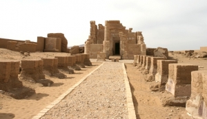
Deir El Hagar (Monastery of the Rock) a temple which was originally dedicated to Amun and his wife Mut and has inscriptions representing religious life. It was later rebuilt by the Romans and it is one of the few Roman ruins in the area. It has been damaged by an earthquake but is said to have been recently restored. It was built during the rule of Nero (45-68 AD)
After exploring the temple, bathe in the hot sulphur spring nearby. Visit Bashendi to see Roman tombs and a factory where carpets are still woven with scenes of Dakhlan life. Bashendi is a village of Pharaonic design located about 40 km. east of Mut. It hosts an Islamic cemetery as well as Roman tombs, the most significant being the Tomb of Kitnes.
At nearby Balat village, a trading post with ancient Nubia, archeologàts are still uncovering dozens of 6th dynasty mastabas. Balat is a small village about 22 miles east of Mut in the Dakhla Oasis and was an important Old Kingdom town. Nearby is the Al-Adaba tombs and Ain Asil. Most notable are the five mastabas, which were discovered during a sandstorm. The best of these is that of governor Medunefer who served during the rule of Pepi II, where funeral artifacts, including gold jewelry were found. The village of Balat itself is picturesque and little changed from medieval times.
Baharyia oasis
Baharyia Oasis
Set in a depression covering over 2000 sq. km., Bahariya Oasis is surrounded by black hills made up of ferruginous quartzite and dolorite. Most of the villages and cultivated land can be viewed from the top of the 50-meter-high Jebel al-Mi'ysrah, together with the massive dunes which threaten to engulf some of the older settlements.
The Oasis was a major agricultural center during the Pharaonic era, and has been famous for its wine as far back as the Middle Kingdom. During the fourth century, the absence of Roman rule and violent tribes in the area caused a decline as some of the oasis was reclaimed by the sand.
Wildlife is plentiful, especially birds such as wheatears; crops (which only cover a small percentage of the total area) include dates, olives, apricots, rice and corn.
There are a number of springs in the area, some very hot, such as Bir ar-Ramla but probably the best is Bir al-Ghaba, about 10 miles north east of Bawiti. There is also Bir al-Mattar, a cold springs which poors into a concrete pool
Otherwise near the Oasis is the Black and White deserts, though traveling to the White desert seems not practical from the oasis. The Black Desert was formed through wind erosion as the nearby volcanic mountains were spewed over the desert floor.
Finally, there are the ruins of a 17th Dynasty temple and settlement, and nearby tombs where birds were buried.
[Bawiti, Bahareya’s capital , is by far the largest village in the Bahariya Oasis with some 30,000 inhabitants. The town center is modern, while outside the center are mud-brick houses. Recently, the town has received considerable press due to the find of a huge (possibly the largest) necropolis of mommies from the Greco-Roman era.
Over time, the Bahariya Oasis has had a number of different names. It has been called the Northern Oasis, the Little Oasis, Zeszes, Oassis Parva and the especially during the Christian era, the Oasis of al-Bahnasa, along with various other names.
Remains of stone tools found in the Bahariya oasis evidence the existence of settlements in the area as early as the Paleolithic Period.
Is seems that the Bahariya Oasis was originally inhabited by a mix of people from the Nile Valley and Bedouins from Libya. At that time, evidence suggests that the Oasis was much larger than it is now, but no settlements dating to the Predynastic, Early Dynastic or Old Kingdom have thus far been unearthed.
By the Middle Kingdom, Bahariya was known as Zeszes, and definitely fell under the control of the Egyptian kings, though only a single scarab (inscribed with the name of Senusret) from that period has been found in Bahariya. Yet, documentary evidence provides that both Amenemhet and Senusret II began to pay considerable attention to the Oasis, probably to deflect regular attacks from the Libyans.
At that time, there must have been large agricultural estates, large houses for the landowners, and even military garrisons to keep marauders at bay. Agriculture was, as it is now, of major importance to this community, and wine, as well as other goods of the Oasis, made their way from here to the Nile Valley by donkey caravans along two different routes.
However, during the 15th Dynasty, when Egypt was under the rule of the Hyksos kings from Palestine, there was a lapse in trade with the Oasis, presumably because the trade routes were unsafe. At that time, we find only one text that refers to the Oasis, when King Kamose refers to it as DjesDjes, the word for the region's famous wine.
Under King Tuthmosis III, many improvements were made in the Oasis, including new water wells. His reign marked an increase in the local population. At this time, the Oasis was under the control of Thinis (Abydos), to which they paid tribute. We find visual evidence of this in the private tomb of Rekhmire, who was Tuthmosis III's vizier. One scene portrays the people of the Oasis, wearing striped kilts, presenting gifts of mats, hides and wine. However, the Oasis apparently had at least a governor who was a native of Bahariya, for the oldest tomb so far discovered in the Oasis is that of Amenhotep Huy, where his title is given as "Governor of the Northern Oasis". The tomb is dated to the end of the 18th Dynasty or the beginning of the 19th. By the 19th Dynasty of Egypt's New Kingdom, the Bahariya Oasis became even more important because of its mineral abundance. Even today, the mining of iron ore continues to be a vital industry. Even Ramesses II, in the Temple of Amun at Luxor, refers to the Bahariya as a place of mining. Of course agricultural products continued to be important in the Oasis, including dates, grapes, figs, livestock and pigeons (for food).
During the 25th and 26th dynasties Bahariya Oasis flourished as an important agricultural and trade center. Specifically, by the 26th Dynasty, Bahariya prospered with its own governors who were natives of the oasis. They apparently continued to report to Abydos, where there apparently remained a governor over all of the Oasis. By the time of Ahmose II (570-526 BC), the importance of the Bahariya Oasis was fully understood. He sent troops into the Western Desert to defend Egyptian interests against the Greeks and Libyans, and acted vigilantly to protect this Oasis. To honor him, two temples were erected, along with a number of chapels near Ain el-Muftella (near El Bawiti). These temples were embellished even into Egypt's Persian period.
During the Persian period that followed a series of takeovers by the Nubians and Assyrians, a strong military presence and garrison were established in the Bahariya Oasis. They may have been responsible for some of the antiquities that have been attributed to the Romans. However, they could not stop the conquest of Egypt by Alexander the Great, once he decided to make Egypt his own.
It is very possible that Alexandria the Great traveled through the Bahariya Oasis on his way to the Oracle of Amun at Siwa. At first, Egypt was a organized under a centrally controlled government headed by Alexander's commander, Ptolemy, and the Bahariya Oasis immediately began to prosper. Not only were trade routes reestablished, but the Greeks used the Oasis to establish control over the rest of the Western Desert. In fact, they set up an extensive, permanent military garrison to protect the trade routes. During the Roman and Greek Periods, we seem to know more about the Bahariya Oasis than from any other period of time. It was during the Greek period that the cemetery known as the Valley of the Golden Mummies came into existence.
During the Greek period, we know that Thoth was worshiped in the Oasis, particularly in his Ibis form, while Hathor is referred to as the "Lady of Bahariya Oasis". Khonsu, the moon god and Amun were both called "Lords of the Bahariya Oasis", though Amun was dominant.
The Romans made many improvements within the Oasis, building an impressive series of aqueducts and wells, several of which are still used in Bawiti and Izza today. This oasis was important to the Romans as a breadbasket, and we find many tombs dug into the sides of the Bahariya mountains during Roman times. There were public works projects, new agricultural communities were formed, roads were cut, and thousands of mud-brick buildings were constructed.
During the Christian period, when Egypt continued under Roman rule, Bahariya was known as the Oasis of al-Bahnasa. There are many churches in the area, including a church named after Saint Bartholomew. There was also a monastery that stood in Bawiti called Dar al-Abras, the Lepers' Refuge, there had been crosses engraved on the walls, paintings, and contained many old writings. At that time the Christians called Bahariya Mari Girgis (St. George).
Bahariya was known as the Northern Oasis, or sometimes as Waha al-Khas during the early Islamic period. How exactly the religious pecking order of the Bahariya was made up during the Christian and Islamic periods is unclear, but it is evident that the Oasis had a considerable Christian community until the 16th or 17th century. Amir Ibn el-As, the commander of the Arab army that conquered Egypt, sent troops to ensure political stability within the Western Desert. During this period, the oasis suffered considerably, as did most places in the Western Oasis; sand dunes covered cultivated land, and the trade in wine was abandoned due to the edicts of Islam. Taxes were now levied against dates and olive oil. Much of this period is relatively unknown to us, but the Fatimids, who had affiliations in Libya, may have crossed the desert in the conquest of Egypt at Bahariya.
Muhammad Ali, often sited as the founder of modern Egypt, made claim to the Bahariya Oasis, as early as 1813 and travelers began to visit the area.
Today, Bahariya's history continues, more detailed than before. Besides archaeologists who seem to have an ever increasing interest in the Oasis, a genealogical history is also kept by several Sheikhs. They not only record births, and deaths, but also surprising events, such as an encounter with a jinn or other supernatural creatures. Three books are kept, including one in Bawiti, another in Mandisha and a third in the area of El Haiz.
Owing to a marked drop in agricultural land bought about by the declining water table under Bahariya, the Oasis suffered a sharp decline in population during the 1950s. It reached a level of no more than about 6,000 residents, but by 1986, the population increased to 20,000 and today there are about 27,000 people living in Bahariya. This is mostly due to a new paved road system established in 1973 over the old caravan routes, allowing a better lifestyle as well as an increase in tourism. Yet the Bahariya Oasis, though the closest to Cairo in kilometers, remains the most distant in time. It has been slow to move into the modern world, a facet that is changing, but for at least the moment, this Oasis offers the visitor a step back in time into medieval streets and a rare, ancient culture
Tiran Island
Tiran Island
The Straits of Tiran, are the narrow sea passages, about 13 km (8 miles) wide, between the Sinai and Arabian peninsulas which separates the Gulf of Aqaba from the Red Sea.
It is named after Tiran Island located at its inflow, on which the Multinational Force and Observers has an observation post to monitor the compliance of Egypt in maintaining freedom of navigation of the straits as provided under the Israel-Egypt Peace Treaty.
Sanafir Island lies to the east of Tiran, southeast of the shallow strait between Tiran and Saudi Arabia.
Access to Jordan's only seaport of Aqaba and to Israel's only Indian Ocean seaport of Eilat is contingent upon passage through the Gulf of Aqaba, giving the Straits of Tiran strategic importance. Egypt's blockade of the Straits to Israeli ships and ships bound for Israel in 1956 and again in 1967 was a catalyst to the Suez Crisis in 1956 and the Six-Day War in 1967.
International documents inconsistently refer to both the "Straits of Tiran" and the "Strait of Tiran". There are several passages formed by the islands between Egypt and Saudi Arabia. The westernmost strait, between Egypt and the island of Tiran, overlooked by the Egyptian city Sharm el-Sheikh is the "Strait of Tiran". It has two passages deep enough to be navigable by large ships. The Enterprise passage, 950 feet (290 m) deep, is right next to the Egyptian side, while the 240-foot-deep Grafton passage, surrounded by shallows, is to the east, nearer to the island of Tiran. To the east of Tiran, between it and Saudi Arabia, the other strait has reefs and shallows with a single channel 54 feet (16 m) deep.
A project to build a 9.3-mile (15.0 km) bridge across the straits, linking Egypt and Saudi Arabia, is under consideration by the Egyptian government. A bridge at this point would bypass Israel, which physically stands between the Arab lands of Africa and the Arab lands of Southwest Asia.
The Blue Hole
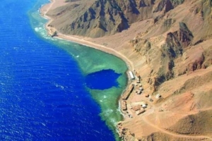
The Blue Hole
is a diving location on the southeast Sinai, a few kilometers north of Dahab
A shore dive and the view is magnificent in this spot where the mountain meets the sea.
The Blue Hole is a submarine sinkhole, with a maximum depth within the hole of just over 100 m (328 feet). There is a shallow opening to the sea around 6 m (20 feet) deep, known as "the saddle", and a 26 m (85 feet) long tunnel, known as "the arch", whose top is at a depth of 55 m (181 feet), and whose bottom falls away as it reaches the seaward side to about 120 m (394 feet).
On the seaward side the depth drops steeply to over a thousand meters (3500 feet) deep.
The hole and the surrounding area have an abundance of coral and reef fish
St katherine Monastary
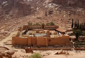
St.Catherine
The town of St. Katherine is in the Sinai Peninsula in Egypt at an elevation of about 1600 meters from sea level, at the foot of the Sinai High Mountains.
the oldest continuously inhabited monastery in the World built on the site where Moses (Prophet Musa) talked to God in the miracle of the Burning Bush, and to climb Mt. Sinai (the Biblical Mt. Horeb, known locally as Jebel Musa) where Moses received the Ten Commandments. Most tourists, up to a 1000 each night, arrive on organized tours from the resort towns of Sharm el Sheikh and Dahab in the evening, climb the mountain at dawn, visit the Monastery in the morning and leave right afterwards. They don't know what they are missing out on: the area has much more to offer than the otherwise indeed spectacular sunrise!
St. Katherine (St. Catherine's City), the Center of the Sinai High Mountain Region.
The region is a UNESCO World Heritage Area for its natural and cultural importance, and in fact, you could spend weeks to explore it. There are over 200 religious places and other important monasteries and churches, ruins of Byzantine monastic settlements, the highest mountains in Egypt with spectacular views, amazing rock formations and landscape. It is a unique high-altitude desert eco-system with many endemic and rare species, there is a whole range of medicinal plants used by locals for centuries which are not found elsewhere, there are water-pools, springs, creeks, narrow canyons and wide valleys. In the valleys of the high mountains, called wadis, everywhere you go there are beautiful Bedouin gardens unique to this area only. Its original inhabitants, the kind and friendly Jebeliya (Gebeliya) Bedouin are expert gardeners and camel herders, and if you take your time you might have a glimpse into their closed, traditional, albeit slowly changing way of life and culture that has been around for more than 1400 years.
For visitors, this site contains practical and background information about the city, the region and its people. For local businesses, projects and the community in general, it provides a web-presence: all listings are free, but entries must be related to the area or its people.
Most people visit St. Katherine (St. Catherine's) from the coastal resort towns -- Sharm el Sheikh, Dahab, Nuweiba, Taba --, but it is also a convenient stop over if you are going from Cairo to the Sinai coast.
Sinai
Sinai Peninsula is the corridor between Africa and Asia. In Pharaonic times the "Way of Horus" & Land of Turquoise.
Later it became the way of Moses and under the mountain where he received the ten commandments is the monastery of St. Catherine. The monastery got special protection from Prophet Mohammed in year 625 and included in Unesco's World Heritage List in year 2002.
When the Holy Family sought protection in Egypt, they came via the North Coast road - and for North African Muslims on Pilgrimage to Mecca, this is their land road.
The peninsula's unique nature matches it's history with the Red Sea in south and the Mediterranean in north.
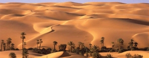
In-between 61,000 square kilometers of desert, mountains and smaller oases. In south the mountains reign while a limestone plateau covers the central area. In north the plateau slopes down to Mediterranean palm beaches.
Some few cities, but a majority of the population is wandering Bedouins where the camel still is an essential part of the society.
Safari to the Sinai peninsula ,the meeting place between the continents of Africa and Asia takes you from ancient turquoise mines to Bedouins in the mountain desert; from the ecosystems of the coral reefs and coastal sand dunes to a majestic view over Sinai from the top of Moses Mountain.
Serabit El Khadem
Serabit El Khadem
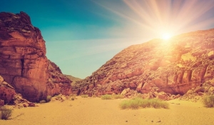
While the Egyptians seem to have known, crossed and visited the Sinai even before the dynastic period, we have found little evidence of their building activities in the region. Of course, inhabitable areas are usually small, and scarce, and so have been inhabited and built upon continuously over the ages.
It is probable that what was built has been built over many times. Today, wondering through the Sinai and viewing its unusual landscape, it is not difficult to imagine a land rich in minerals.
Egyptians discovered its mineral wealth very early on, perhaps at the beginning of the dynastic period. Archaeologists have found that the very earliest known settlers in the Sinai, about 8,000 years ago, were miners. Drawn by the region's abundant copper and turquoise deposits, these groups slowly worked their way southward, hopping from one deposit to the next. By 3500 BC, the great turquoise veins of Serabit el-Khadem had been discovered.
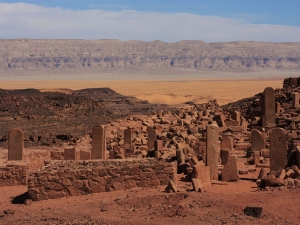
The ancient mining complex of Serabit el-Khadem lies on a small plateau north of modern Al-Tor. It is located about halfway down the western coast about ten miles from Wadi Mughara. It was one of the most important sites for the Egyptians on the peninsula. Today, it is not difficult to reach the Serabit el-Khadem area, though the trip must be made by jeep. There are no paved roads to the base of the mountain. Although many of the region's pharaonic reliefs were destroyed by a British attempt to re-open the mines in the mid-nineteenth century, along the path to the temple are a number of engravings that were written by the ancient minors.
Some of the most interesting portray the ships that would carry the turquoise to Egypt. There is also an excellent bas relief of King Sekhemkhet on the east face of the plateau, revealing him smiting Egypt's enemies. Other antiquities are found along the path, including ancient tunnels, miner's huts and stele.
The temple at Serabit el-Khadim, though really only scattered ruins, is one of the few phraonic monuments we know of in the Sinai. Here it was found the famous proto-Sinaitic script", which is believed to be an early precursor of the alphabet. These scripts were hieroglyphic signs used to write the names of the West Semitic names of the people who worked the mines, and keep account of their labors. They developed an alphabet with which they could record their Proto-Canaanite language. The script they developed is called Proto-Sinaitric (First-Sinaitic) and the language was a Pan-Canaanite language often called Old Hebrew
The Serabit El Khadim temple looks like a double series of steles leading to an underground chapel dedicated to the Hathor Goodness.
Most of the temple’s large number of sanctuaries and shrines were dedicated to Hathor, among her many other attributes; she was the patron goddess of copper and turquoise miners. It is the only temple we know of, built outside mainland Egypt and mostly dedicated to Hathor. The earliest part of the main rock cut Hathor Temple, which has a front court and portico, dates to the 12th Dynasty The temple was probably founded by Amenemhet III, during a period of time when the mines were particularly active. The 12th Dynasty was a period of considerable mineral wealth for Egyptians and some of the finest jewelry from Egypt's past have been discovered in the tombs of 12th Dynasty women.
A number of scenes portray the role of Hathor in the transformation of the new king, upon ascending the throne, into the deified ruler of Egypt. One scene, for example, depicts Hathor suckling the pharaoh. Another scene from a stone tabled depicts Hathor offering the pharaoh the Ankh.
This older part of the temple was enlarged upon and extended by Queen Hatshepsut, along with Tuthmosis III and Amenhotep III during the New Kingdom. This was a restoration period for the mining operations after an apparent decline in the area during the Second Intermediate Period. These extensions are unusual for a temple in the manner in which they angled to the west off of the earlier structure.
On the north side of the of the temple is a shrine dedicated to the pharaohs who were deified in this region. On one wall of the shrine are numerous stele. A little to the south of the main temple we also find a shrine dedicated to the god of the eastern desert, Sopdu, which is smaller then the northern shrine.
Ras Mohamed
Ras Mohamed
Ras Mohamed is located at Gulf of Aqaba on an area of 480 square kilometers.
It is the headland at the southern most tip of the Sinai Peninsula, overlooking the juncture of the Gulf of Suez and the Gulf of Aqaba. The islands of Tiran and Sanafir are part of the site. Littoral habitats include a mangrove community, salt marshes, inter-tidal flats, a diversity of shoreline configurations and coral reef ecosystems that are internationally recognized as among the world's best.
In addition a diversity of desert habitats such as mountains and wadis, gravel plains and sand dunes.
More than 200 species of corals, where 125 species are soft corals, around 1000 species of fish, 40 species of star fish, 25 species of sea urchins, more than a 100 species of mollusc and 150 species of crustaceans. Ras Mohammed is important as a bottleneck for migratory soaring birds. The majority of the world populations of white stork Ciconia ciconia pass through this area. The islands of Tiran and Sanafir hold important breeding populations of the threatened and endemic White-eyed Gull Larus leucophthalamus and Osprey Pandion haliaetus.
The island of Tiran has one of the largest recorded Osprey populations in the Red Sea. The threatened Green Turtle Chelonia mydas and Hawksbill Turtle Eretmochelys imbricata occur off Ras Mohammed regularly.
The threatened mammal species include Dorcas Gazelle Gazella dorcas, Nubian Ibex Capra ibex nubiana tourism in Southern Sinai is inherently linked to the natural resources of the area. Degradation of these natural resources as a result of tourism or development activities is not in the best interests of investors or tourists.The Protected areas program seeks to establish equilibrium between development activities, tourism and the natural resource conservation measures needed to achieve sustainable economic development.
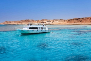
Due to Ras Mohamed’s geographical position, divers find almost permanent strong currents during all the year, which attracts larger fish. Beautiful beaches, extraordinary coral reefs and exciting dive sites make Ras Mohamed National Park a worthwhile visit.
Coral reef ecosystems found in the National Park are recognized internationally as among the world's best. This recognition is based primarily on the diversity of flora and fauna, clear warm water devoid of pollutants, their proximity to shorelines and their spectacular vertical profile. The reef exists as an explosion of color and life in stark contrast to the seemingly barren desert adjacent to it. In reality, the desert is rich in fauna, mainly nocturnal. These ecosystems are intrinsically linked and thus must be managed as a single unit
Ras Abu Galum
Ras Abu Galum
Abu Galum
It is located in the north east of south Sinai, near by the Gulf of Aqaba. It’s area measures 500 square kilometers
Abu Galum is one of the picturesque nature reserves in the country. With its high mountains, narrow sinuous valleys (wadis), freshwater springs, coastal sand dunes, gravel alluvial fans, raised fossil coral reefs and low lying saline sabkha, it is not surprising that this small area of the Sinai peninsula houses 165 plant species.
Of these, 44 species are seen only in this reserve and tend to increase in density towards central and northern Sinai.
As a floristic frontier, Abu Galum reserve is a sensitive area that receives a high conservation priority. Access to regions without vehicle track systems can only be permitted where marked trails have been prepared.
The managed resource protected area at Abu Galum, covering an area of 400 km square, protects varied coastal and mountain ecosystems unique on the Gulf of Aqba.
The area differs dramatically from the other reserves on the Gulf. The coastal area contains undisturbed coral reefs with high diversities of coral reef fish and associated fauna and flora. Evidence of the richness of the area could be seen on the shorelines covered with shells of various mollusk groups.
The reef at Abu Galum supports an active Bedouin artisanal fishery. The fishery is now being regulated by Egyptian Environmental Affairs Authority (EEAA) to reduce damage to the coral reef. The reef could be viewed at marked, safe access entry points.
Terrestrial areas in Abu Galum nature reserve park are a stark contrast to the exuberance of colour and life seen on the coral reef. Seemingly devoid of visible life, they are in fact home to the desert fox, Nubian Ibex (in the mountain areas), numerous small mammal species, reptiles and insects. Most of this fauna is difficult to see given their nocturnal habits. Foxes are often seen in the vicinity of Yolanda Beaches. They are harmless if approached with care; they should not be fed but can be provided with water. Fox cubs could be seen at sunset in springtime. All other wildlife should not be approached.
The park is also home to important resident bird populations including Grey Heron, Goliath Heron, Reef Heron and their small relative, the Greenback Heron. At least 5 groups pf Osprey (a fish-eating falcon) are resident and breeding annually. In summertime thousands of White Stork stop over in the park during their annual migration to East Africa.