+2 0122-345-3028
This email address is being protected from spambots. You need JavaScript enabled to view it.

Super User
Luxor
Luxor
Luxor is located 670 km south of Cairo. It is considered as the greatest outdoor museum in the world as it contains nearly one third of the world’s antiquities. There is hardly a place in Luxor which has not a relic that reflects the greatness of the ancient Egyptians and their civilization that dates back to seven thousands years ago.
Luxor is part of the ancient “Thebes” that the renowned Greek poet Homer describes as “the city of one hundred gates”. It remained the seat of power from 2100 to 750 BC.
The Arabs called it Luxor meaning the city of Palaces, because they were impressed by its magnificent edifices and huge buildings.
Luxor still attracts hordes of visitors, from all over the world to enjoy the monuments of the eternal city and its temples with their towering pillars on the two banks of the Nile. The City of the living on the east bank where sunrise is source of life and growth and the City of the dead on the West Bank where sunset symbolizes the eclipse of Life.
On the East Bank stand the Luxor Temple, a graceful ornament on its waterfront and downtown quarter, while just to the north is Karnak Temple, a stupendous complex built over 1300 years.
Across the river on the West Bank are the amazing tombs and mortuary temples of the Theban necropolis: the Valley of the Kings, the valley of the queens, Hatshepsut temple, valley of the artisans, valley of the nobles and Memnon Colosse
Recently, a bridge connecting the east and the west banks has been constructed to speed up tourist traffic to the West Bank.
Luxor also serves as a base for trips to Esna, Edfu, Dendara and Abydos Temples up and down the Nile valley.
You can enjoy the wonderful tourist sites of Luxor soaring in a balloon above the temples on the east and west banks which lasts for one and half hour!
Kom Ombo
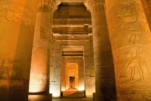
Kom Omb
The Town of Kom Ombo is located about 41 miles south of Idfu and 28 miles north of Aswan.
Kom Ombo is the ancient site of Ombos, which is from the ancient Egyptian word 'nubt', which means 'City of Gold'.
It has been occupied since prehistoric times.
In ancient Egypt, the city was important to the caravan routes from Nubia and various gold mines.
The local industry is primarily agriculture, including irrigated sugar cane and corn.
Besides the native Egyptians, there is a large population of Nubians who were displaced from their land when Lake Nasser was created.
The major attraction here is the Temple of Kom Ombo, located on a hill west of the village. There is a wonderful view of the countryside from the Temple, and south of here is the Roman Chapel of Hathor.
Kharga
Kharga
Kharga Oasis is the last oasis on the loop before the Nile Valley. It seems to have had the longest association with ancient Egypt. It is also the place where Christians were banished in the 4th and 5th centuries and as a souvenir of the time boasts one of the largest ancient Christian cemeteries in the world: Bagawat. Kharga also claims the first five star resort with swimming pool and air conditioning. At first glance Kharga looks disappointing for its main village is a replica of a Nile Valley town, but one must dig deeper.
Kharga used to be the last but one stop of The Forty Days Road, the infamous slave-trade route between North Africa and the tropical south. Today, it is the biggest New Valley oasis and its modern city houses 60,000 people, including 1,000 Nubians who moved here after the creation of lake Nasser.
Outside the main center is the Temple of Hibis, built on the site of an 18th dynasty settlement of Saites, Persians and Ptolemies. One of the few Persian monuments in Egypt, the 6th century BC temple is well preserved with painted vultures and huge reliefs of Darius greeting Egyptian gods on the outer walls. The temple is dedicated to the Theban triad, consisting of the gods, Amun, Mut and Khonsu, who's reliefs are in very good condition.
Ten kilometers away, the Necropolis of al-Bagawat contains 263 tombs (mostly dating from the 4th through 6th centuries, AD) in the pattern of domed chambers, as well as 120 Nestorian mud brick chapels where the dead could be worshipped.. Some of the tombs have paintings of biblical scenes. In the center is a church dating back to the 11th century AD. It is regarded as one of the oldest churches in Egypt.
Some of the more interesting structures located here include the Chapel of Peace, with paintings of the apostles and with images of Adam and Eve and the Ark on it's dome. There is also the Chapel of Exodus, with better preserved pictures, and Old Testament biblical stories as well as frescoes of pharaonic troops pursuing the Jews, led by Moses, out of Egypt. Another example is the Chapel of the Grapes, with paintings of grapevines. Pharaonic monuments include the al-Ghuwaytah Temple which dates from 522 BC and the Temple of Amenebis.
The thermal springs at Bulaq and Nasser villages to the south, are famous for water temperatures of up to 43 C and reputed to be suitable for the treatment of rheumatism and allergies. Camping facilities are available near both villages.
Further south is Baris Oasis, the second largest settlement in Kharga. Houses designed in traditional Nubian style.
Ancient monuments include the Temple of Dush, dedicated to Isis and Serapis. Its name derives from Kush, the ancient Sudanese capital which traded with Egypt along the Nile. Dush was a religious, military and civilian complex that primarily developed as the result of the slave trade, and was a staging point for caravans that either headed to Assiut or Esna.
Built for Isis and Serapis, this temple is surrounded by a mud-brick fortress. It was built during the rule of Domitian and Trajan (1st century) and decorated during the rule of Hadrian, though apparently the site was occupied from the Ptolemaic period. Entering the temple through any one of several gates is the barrel-vaulted sanctuary which is made up of two connecting rooms and has a vaulted ceiling. On either side of the sanctuary are chapels.
Archeologists are still unearthing the ancient city of Kysis and elaborate system of clay pipes and abandoned Christian church, suggest that Kysis was abandoned when its underground springs dried up but the exact date remains a mystery.
Kharga Oasis’s greatest treasures, in addition to its marching rows of crescent sand dunes, are the Roman fortresses scattered along a famous slaver’s road called the Darb el Arbain, the 40 Days’ Road. These unexplored fortresses rise to four and five stories. And there are dozens of them.
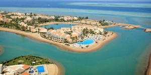
Hurghada
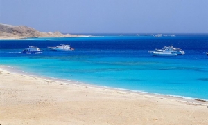
Hurghada
Hurghada was founded in the early 20th century, and until a few years ago, remained a small fishing village. But today, it has gone on to become the foremost tourist resort of the Red Sea coast and an international center for aquatic sports. If it takes place in or on the water you can do it here: windsurfing, sailing, deep-sea fishing, swimming, but, above all, snorkeling and diving. The unique underwater gardens offshore are some of the finest in the world, justifiably famous amongst divers. The warm waters here are ideal for many varieties of rare fish and coral reefs, which may also be observed through glass bottom boats. This area has many fine accommodations, usually offering warm and efficient service. Restaurants are mostly along the main road. While in Hurghada, don't miss the museum and aquarium, with their complete collections of flora and fauna of the Red Sea.
Today, Hurghada is known as a party town, particularly among Europeans. Locals and others will tell you that life begins at night in Hurghada, with the many, many clubs. They are particularly frequented by the young, but certainly many others of all ages. One may often find a rousing party centered on the visitors from a tour group taking over the action of a particular bar.
They are easy to find along the main street, along with loads of inexpensive and expensive hotels.
it is also a beach resort, where thousands of older Europeans and others come with their families to enjoy the sun and fun of private resort beaches, some all inclusive. Many of these hotels offer so many activities and facilities that one may never need to leave the resort. Often, the larger resorts have zoos, playgrounds, discos, bars, a number of pools and even small theaters.
Hurghada is also a city under development. Many new hotels and construction are taking place, and we can expect to see some great new hotels, restaurants and other facilities in the near future. To the North of Hurghada is El Gouna, a highly organized resort community.
Together, these communities and resort areas offer just about everything a visitor might wish for, from raucous parties to isolated scuba diving, with golf, bowling and fishing in between.
Islands near Hurghada offer all kinds of fun and excitement. Take a day trip to Giftun Island for diving, snorkeling and a fish barbecue, or view the Red Sea from a submarine! When you're not in the sea you can shop in the boutiques, relax in the luxury holiday villages or visit the Roman Mons Porphyrites (mountain of porphyry) remains at nearby Gebel Abu Dukhan (Father of Smoke).
Day-trips or safaris to explore the Red Sea Mountains by camel or jeep are also available. Other nearby islands and destinations include Shaab el-Erg (Diving, fishing and snorkeling), Umm Gammar Island (Diving and snorkeling), Careless Reef (Diving), Abu Ramada Island (Diving), Shaab Abu Ramada (Fishing), Dishet el-Dhaba (Beaches and swimming), Shaab Abu Hashish (Beaches, diving, snorkeling, swimming and fishing) and Abu Minqar Island (Beaches and swimming).
Fayoum
Fayoum
The Fayoum is a wonderful area of Egypt with a rich and interesting history. It is an area where Egyptians often vacation and which is constantly growing more popular among Europeans. This 692 sq. mile depression was a lush paradise during prehistoric times. It's water level was eighty-five meters higher than today (currently 45 meters below sea level) and the Nile regularly flooded through the low mountains separating it from the Fayoum. At 215 square km, the current lake Qaroun remains Egypt's largest salt water lake. The prehistoric people who lived here were, at first, nomadic hunters and gatherers, but later began harvesting plants near the lake. This developed into what is said to be the earliest agricultural area in the world, where fences were erected and guarded warehouses built. It has remained an agriculture center, well known for it's fruits, vegetables and chickens.
During the Middle Kingdom, the region achieved considerable importance and large monuments were built around its shore. Lahun and Hawara, on the ridge dividing the Fayum from the Valley, were chosen for the construction of two pyramids, both of which are now in ruins. The funerary complex at Hawara, built by the XII Dynasty king Amenhotep III, consisted of a pyramid and a large funerary temple. Thirteen centuries after its construction, it was visited by the Greek traveler and historian Herodotus, who described it as a labyrinth.
Excavated by the British archaeologist Petrie in the years 1888-1910, the site unfortunately revealed almost nothing of the wonderful building that once must have been there. These were life-size portraits of people of the community living there, which were kept in the houses and then placed as funerary masks on the mummy of the deceased. The Roman cemetery north of Hawara, instead, yielded one of the most important archaeological findings of the area, the so-called Fayum Portraits. These Greek mummy portraits found in the Fayoum are said to be the worlds first true life portraits, and examples can be found in area museums.
In addition, a paved road, which has been noted as a landmark of engineering by engineering societies along side the Eiffel Tower and Statue of Liberty, is said to be possibly the first paved road in the world and dates to over 4,500 years. And finally, the worlds first dam was probably built here in order to control the Nile floods into the area.
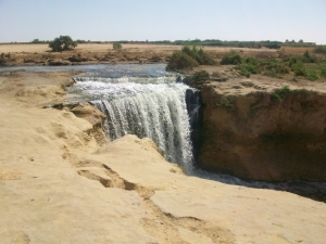
The peacefulness of the area is a relief from the hustle and bustle of Cairo, from which it is a brief trip. Bird life still abounds around Lake Qaroun, bordered by semi-nomadic Bedouin settlements and fishing villages. Here, on the edge of the desert, you can sail, windsurf, swim and fish. Other places of outstanding natural beauty near Fayoum are the hot springs at Ain al-Siliyin, where you can bath and the waterfalls at Wadi al-Rayan, 40km towards Bahariya, also suitable for swimming and picnics.
Fayoum is not a true oasis since it depends on Nile water instead of underground springs or wells. The ancient Bahr Yussef canal runs through the center of the city and irrigates the land. Only two hours from Cairo by road, Fayoum is renowned for its year-round warm climate, numerous water wheels (introduced by the Ptolemies in the 3rd century) and lush agricultural land. Cotton, clover, tomatoes, medicinal plants and fruit are all grown here. The local Souk (market) in Fayoum City sells copperware, spices and gold jewelry and there is a special pottery market once a week.
Other interesting archaeological sites are the unusual Middle Kingdom temple at Qasr el-Sagha, the town of Medinet Madi, with a Middle Kingdom temple later expanded by the Ptolemies, the Late Period town of Dionysyas (today called Qasr Qarun) at the western end of Birket Qarun and the large Roman Bath at Kom Aushim. Other sites, such as Medinet Fayum (the ancient Crocodilopolis) or Darb Gerze (the ancient Philadelphia) have revealed important archaeological evidence.
Farafra
Farafra
Farafra, known as Ta-iht or the Land of the Cow in pharaonic times, is a single village. The most isolated of the New Valley Oases it is renowned for its strong traditions and piety. According to folklore, the villagers once lost track of time and had to send a rider to Dakhla so they could hold the Friday prayers on the right day. The oldest part of the village, on a hillside, is next to peaceful walled palm groves; a short ride away there are hot sulphur springs at Bir Setta and swimming at El-Mufid Lake.
Mostly inhabited by Bedouins, the small mud-brick houses all have wooden doorways with medieval peg locks. As in other oases, many of Farafra's houses are painted blue (to ward off the Evil Eye) but here some are also decorated with landscapes, birds and animals, the handiwork of local artist, Badr. A combination house, museum and studio exhibiting his paintings and ceramics is situated in a garden full of sculptures made from objects found in the surrounding desert.
The only real village in the Farafra Oasis, Qasr Al Farafra is a quite and relaxing place, which represents most of what it has to offer tourists. There are few tourist accommodations in the area, but that may change in the near future. Most of the description of the Farafra Oasis applies to the town itself.
The White Desert ,20 km from Farafra on the Highway between Farafra and Bahariya, is one of the most exiting places. A surreal landscape of fungoid shapes that glint pale gold in the midday sun and turn pink and violet around dusk, resembling icebergs at dawn and snowdrifts by moonlight, the chalk outcrops loom over dusty ground littered with fossils, quartz crystals and iron pyrites shaped like sea-urchins or twigs. Herds of gazelles may be glimpsed at daybreak, when they forage for a couple of hours.
Of those with an interest in Egypt, and particularly the Western Oasis, the Farafra is probably one of the least known Oasis. It is actually one of the most difficult Oasis to reach and offered the pharaohs, caliphs and kings very little, though it seem to be on the way to everywhere.
There is actually very little known of the Farafra Oasis prior to the Roman period, and even of that period only a few remains have been found. While the oasis offers a stunning desert landscape, there is little in the way of antiquities to see. According to a statue of the 5th Dynasty, Farafra, as well as the Bahariya Oasis were probably a part of the Egyptian empire during the Old Kingdom. It was known as the Trinitheos, Ta-ihw, and the Land of the Cow (in reference to Hathor). It was often invaded whenever the Libyans decided to attack Egypt, being on their way to the Nile Valley. Though we have little idea what the reference refers to, the text known as the Eloquent Peasant refers to the "rods of Farafra" in relationship to produce, giving us at least a citation to the oasis during the First Intermediate Period.
During the New Kingdom there is somewhat more evidence that comes to us from the Farafra Oasis. A stela was discovered in the Oasis dating to the 18th Dynasty, but it provides little information. However, we find documentary records from the reign of Ramesses II in the Temple of Luxor that he received precious stones form Farafra that were used in some of his extensive building works along the Nile Valley. However, the references does not provide information on the type of stones, and no evidence of ancient mining activities have so far been unearthed in the oasis. What is known is that during the 19th Dynasty reign of Merenptah, Ramesses II's son and successor, the oasis was captured by Libyan invaders who used it as a base to attack the Nile Valley. As a side note, the Farafra Oasis is actually closer to Libya than to the Nile Valley.
During the Third Intermediate Period, though little supporting evidence is available, the Farafra may have been an important way station for both armies and trade caravans. We do know that there were several major caravan routes that operated through the Farafra during this period.
Though the quantity is small, the earliest antiquities currently found in the Farafra Oasis date from the Roman Period. During that time, it probably held some real importance for the Romans because it sat at the center of their African holdings, connecting the Nile Valley to the Libyan oasis such as Jalo and Kufra. So far, the Roman antiquity sites found in the Oasis are actually at Ain Della, now often called the "Hidden Valley", which is actually a separate depression just north of Farafra, with others found at Wadi Hinnis along the main caravan route to the Bahariya Oasis, and at Ain Besay just to the south of Qasr Farafra.
During the Roman Byzantine Period, the oasis mostly converted to Christianity and remained Christian far into the Islamic era, even though it was, the first Western Desert oasis conquered by the Arabs. Little evidence exists that it became a place of banishment like the Siwa and Kharga Oasis, but it is likely to have been, given its remote location. We do find a number of Coptic inscriptions in the oasis, as well as clearly Christian houses and cemeteries dating to the 10th century.
Actually, the Islamic religion did not enter the Farafra Oasis from the Nile Valley, but rather from North Africa. Our first reference of the oasis during the early Islamic period is the Kitab al-buldan by al-Yaqubi written during the 9th century. It says of the Farafra that the oasis was inhabited by people of "all descents". This document was written at about the time that the oasis began to be converted to the Islamic faith.
The Arab rulers of Egypt maintained a relatively large army in the desert. Unfortunately, this was a difficult period for many people in the Western Oasis, and like elsewhere, the Farafra was almost depopulated by the Mamluk rule of Egypt.
Today, Farafra has not just entered the new world, though its essence remains elusive and mysterious, the oasis is scheduled to add new chapters to world history. As a part of the visionary New Valley Project, soon Farafra will change forever. With many incentives for Egyptian families to move to the New Valley in order to elevate overcrowding in current urban centers, there are many more villages in or near the Oasis , and each is provided with a school, a hospital and a mosque. Industry is also arriving in the oasis in the form of Fiber optics!
The Farafra is also being developed for tourism, and while there are few ancient artifacts in the region, the desert is wonderfully diverse
Esna
Esna
Esna is located about 33 miles south of Luxor. The town's Greek name was Latopolis and here fish where thought to embody the goddess Neith, who was sacred to the area.
Esna was increasingly important during the 18th dynasty due to Egypt's developing relationship with the Sudan.
There was a route established between Esna and Derr.
Later, the city slowly declined until it received renewed interest during the 26th Dynasty.
Later, under the Greeks and Romans, it became the capital of the Third Nome of Upper Egypt.
There is also a barrage just outside of town which was built in 1906. About 4 miles southwest of town is the Deir Manaos WA al-Shuhada (Monastery of the Three Thousand Six Hundred Martyrs), who's 10th century church is said to be one of the most beautiful in Upper Egypt.
Perhaps this monastery is a lasting commemorative to Emperor Decius (249-51 AD) who degreed that all Christians would suffer death if they did not sacrifice to the pagan gods.
His cartouche was the last to be carved on the walls of the Temple of Khnum in Esna.
But the main attraction is the Temple of Khnum, which lies beneath the level of the houses in a pit.
Near the Temple of Khnum on the stone quay along the corniche are carved cartouches of Emperor Marcus Aurelius.
EL Quseir
EL Quseir
Quseir is located 80 Km South of Safaga. It is known in Ptolemaic times as the White Harbor and has a long history as one of the major ports of the Red Sea. From here, Queen Hatshepsut launched her expedition to the Land of Punt, as depicted in the reliefs in Deir el-Bahari temple at Luxor.
Legend has it that the expedition returned with two live panthers and 21 incense trees. The 16th century fortress of Sultan Selim, still standing in the center of town, shows al-Quseir's former strategic importance.
Today, it is a quiet resort with sandy beaches, clear waters and coral reefs. The town's narrow streets are lined with colorful bazaars which have a decidedly Bedouin accent. An ancient caravan trail, to Qift in the Nile Valley, leads from al-Quseir through the mountains, passing several Pharaonic and Roman sites. A new road, directly to Luxor, opens soon.
Quseir is also famous with its beaches, water sports and above all the diving. The primary dive sites in the area include: Shoona Ras Torombi, Habili Sheik, Marsa Wizri, Sharm El Quibli, Mangrove Bay, Erg El Esel, Queseir El Qadim and the Brother Islands
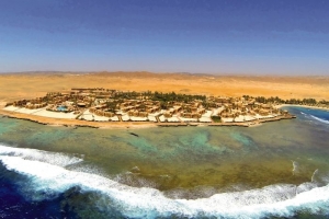
El Gouna
El Gouna
Encounter plenty of interconnected islands while scout around the major landmarks of El Gouna the twinkling resort, El Gouna located at Hurghada, with its fascinating landscapes, wonderful lagoons, excellent golf gardens for golfers and a variety of water sports you can practice there like wind and kit surfing, El Gouna is an environmentally friendly destination complete with world class accommodations for all family members that offers a myriad of services and activities to suit everyone.
an amazing holiday and became one of the most luxury resorts in the world, because it offers plenty of Olympic Pools, tennis courts, cosmopolitan restaurants and cafes, besides it’s remarkable resort for honeymooner with its privacy, safety and fascinating atmosphere that attract large number of Honeymooners, And if you're in the mood for a little cultural adventurous escape, head to the nearby desert where you'll be offered a glass of tea by the Bedouins and enjoy gazing at the stars in the cloudless desert sky.
this town is built in a traditional Egyptian style with inner courtyards, winding alleys & rolling domes, all surrounded by turquoise lagoons.
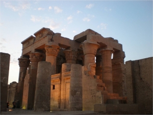
Edfu
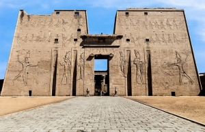
Edfu
The town of Edfu is located on the west back of the Nile River, 60 miles south of Luxor and 65 miles north of Aswan.
Its ancient name was Wetjeset-Hrw, or "The Place Where Horus is extolled".
The modern Arabic name of Edfu is derived from the ancient Egyptian name Djeba, or Etbo in Coptic. Djeba meant "Retribution Town", since the enemies of the god were brought to justice therein. The site of ancient Djeba was the traditional location of the mythological battle between the gods of Horus and Set.
Edfu was the Greek city of Apollinopolis Magna, and is a religious and commercial center.
It is a friendly town which produces surgar and pottery. It is also a hub of a road network.
It was the capital of the second nome (Horus) of Upper Egypt.
The main attraction here is the Temple of Horus, which is considered by most to be the best preserved cult temple in Egypt, but there is a mound of rubble to the west of the Temple which is probably the original old city of Djeba.
It was the capital of the second nome (Horus) of Upper Egypt. Here it was found Old Kingdom mastabas and Byzantine house.