+2 0122-345-3028
This email address is being protected from spambots. You need JavaScript enabled to view it.

Super User
Sinai
Sinai
Sinai Peninsula is the corridor between Africa and Asia. In Pharaonic times the "Way of Horus" & Land of Turquoise.
Later it became the way of Moses and under the mountain where he received the ten commandments is the monastery of St. Catherine. The monastery got special protection from Prophet Mohammed in year 625 and included in Unesco's World Heritage List in year 2002.
When the Holy Family sought protection in Egypt, they came via the North Coast road - and for North African Muslims on Pilgrimage to Mecca, this is their land road.
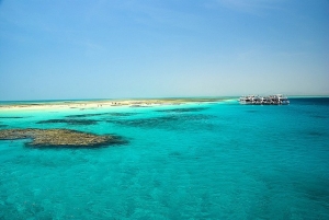
The peninsula's unique nature matches it's history with the Red Sea in south and the Mediterranean in north.
In-between 61,000 square kilometers of desert, mountains and smaller oases. In south the mountains reign while a limestone plateau covers the central area. In north the plateau slopes down to Mediterranean palm beaches.
Some few cities, but a majority of the population is wandering Bedouins where the camel still is an essential part of the society.
Safari to the Sinai peninsula ,the meeting place between the continents of Africa and Asia takes you from ancient turquoise mines to Bedouins in the mountain desert; from the ecosystems of the coral reefs and coastal sand dunes to a majestic view over Sinai from the top of Moses Mountain.
The most important Safari destinations:
- Ain El Furtaga
16 km from Nuweiba by road. Palmy oasis at the crossroads of trails to the Coloured Canyon, Wadi Ghazala and Ain Khudra Oasis.
- Ain Hudra Oasis
One of the loveliest oasis in Sinai. Nature has carved the sandstone to fascinating shapes. The yellow and brown of the desert canyon give way to green when reaching the Ain Hudra Oasis. Here we can explore the big palm trees forest and the gardens of olives, grapes and orange close to the spring of water. Bedouins have their little houses on the slopes leading up the mountain sides
- Ain Kid Oasis
14 km off the road between Sharm El Sheikh and Dahab; reached via Wadi Kid, a red-walled canyon where a spring appears in rainy years. The Oasis has a fresh-water well.
- Nuwamis
Prehistoric site with 5550-year-old graves and inscriptions
- Wadi Ghazala
Named after the gazelle deer living there, it links Ain El Furtaga and Ain Hudra oasis. Acacia groves, dunes and gazelles are to be seen there.
- Hamam Faraoun
It lies 55 km south of Ras Sudr ( Pharaoh’s Bath)
- Wadi Widai
This area is a valley surrounded by Granite mountains of varying colours and shapes
- Abu Galum
It is located in the north east of south Sinai, near by the Gulf of Aqaba. It’s area measures 500 square kilometers
Abu Galum is one of the picturesque nature reserves in the country. With its high mountains, narrow sinuous valleys (wadis), freshwater springs, coastal sand dunes, gravel alluvial fans, raised fossil coral reefs and low lying saline sabkha, it is not surprising that this small area of the Sinai peninsula houses 165 plant species.
Of these, 44 species are seen only in this reserve and tend to increase in density towards central and northern Sinai.
As a floristic frontier, Abu Galum reserve is a sensitive area that receives a high conservation priority. Access to regions without vehicle track systems can only be permitted where marked trails have been prepared.
The managed resource protected area at Abu Galum, covering an area of 400 km square, protects varied coastal and mountain ecosystems unique on the Gulf of Aqba. The area differs dramatically from the other reserves on the Gulf. The coastal area contains undisturbed coral reefs with high diversities of coral reef fish and associated fauna and flora. Evidence of the richness of the area could be seen on the shorelines covered with shells of various mollusk groups.
The reef at Abu Galum supports an active Bedouin artisanal fishery. The fishery is now being regulated by Egyptian Environmental Affairs Authority (EEAA) to reduce damage to the coral reef. The reef could be viewed at marked, safe access entry points.
Terrestrial areas in Abu Galum nature reserve park are a stark contrast to the exuberance of colour and life seen on the coral reef. Seemingly devoid of visible life, they are in fact home to the desert fox, Nubian Ibex (in the mountain areas), numerous small mammal species, reptiles and insects. Most of this fauna is difficult to see given their nocturnal habits. Foxes are often seen in the vicinity of Yolanda Beaches.
They are harmless if approached with care; they should not be fed but can be provided with water. Fox cubs could be seen at sunset in springtime. All other wildlife should not be approached.
The park is also home to important resident bird populations including Grey Heron, Goliath Heron, Reef Heron and their small relative, the Greenback Heron. At least 5 groups pf Osprey (a fish-eating falcon) are resident and breeding annually. In summertime thousands of White Stork stop over in the park during their annual migration to East Africa.
- Colored Canyon
It lies between St. Catherine's Monastery and the town of Nuweiba. It is a natural formation of sandstone and limestone of various colours worn away over the centuries by rains draining from the mountain top. Exquisite patterns have been formed of a myriad colours forming patterns of all shapes and sizes. Some resemble woodgrain – others surrealism paintings – but these are note man made. Different shapes and colours greet you upon every turn.
It has become a popular safari trek and The strange rock formations and the rainbow- hued colored canyon walls are dramatic and the silence within -only adds to the oddity. Great for walking or rock-climbing
- Serabit El Khadem
While the Egyptians seem to have known, crossed and visited the Sinai even before the dynastic period, we have found little evidence of their building activities in the region. Of course, inhabitable areas are usually small, and scarce, and so have been inhabited and built upon continuously over the ages. It is probable that what was built has been built over many times.
Today, wondering through the Sinai and viewing its unusual landscape, it is not difficult to imagine a land rich in minerals. Egyptians discovered its mineral wealth very early on, perhaps at the beginning of the dynastic period. Archaeologists have found that the very earliest known settlers in the Sinai, about 8,000 years ago, were miners.
Drawn by the region's abundant copper and turquoise deposits, these groups slowly worked their way southward, hopping from one deposit to the next. By 3500 BC, the great turquoise veins of Serabit el-Khadem had been discovered.
The ancient mining complex of Serabit el-Khadem lies on a small plateau north of modern Al-Tor. It is located about halfway down the western coast about ten miles from Wadi Mughara. It was one of the most important sites for the Egyptians on the peninsula. Today, it is not difficult to reach the Serabit el-Khadem area, though the trip must be made by jeep. There are no paved roads to the base of the mountain. Although many of the region's pharaonic reliefs were destroyed by a British attempt to re-open the mines in the mid-nineteenth century, along the path to the temple are a number of engravings that were written by the ancient minors. Some of the most interesting portray the ships that would carry the turquoise to Egypt. There is also an excellent bas relief of King Sekhemkhet on the east face of the plateau, revealing him smiting Egypt's enemies.
Other antiquities are found along the path, including ancient tunnels, miner's huts and stele.
The temple at Serabit el-Khadim, though really only scattered ruins, is one of the few phraonic monuments we know of in the Sinai. Here it was found the famous proto-Sinaitic script", which is believed to be an early precursor of the alphabet.
These scripts were hieroglyphic signs used to write the names of the West Semitic names of the people who worked the mines, and keep account of their labors. They developed an alphabet with which they could record their Proto-Canaanite language. The script they developed is called Proto-Sinaitric (First-Sinaitic) and the language was a Pan-Canaanite language often called Old Hebrew
The Serabit El Khadim temple looks like a double series of steles leading to an underground chapel dedicated to the Hathor Goodness. Most of the temple’s large number of sanctuaries and shrines were dedicated to Hathor, among her many other attributes; she was the patron goddess of copper and turquoise miners. It is the only temple we know of, built outside mainland Egypt and mostly dedicated to Hathor. The earliest part of the main rock cut Hathor Temple, which has a front court and portico, dates to the 12th Dynasty The temple was probably founded by Amenemhet III, during a period of time when the mines were particularly active. The 12th Dynasty was a period of considerable mineral wealth for Egyptians and some of the finest jewelry from Egypt's past have been discovered in the tombs of 12th Dynasty women.
A number of scenes portray the role of Hathor in the transformation of the new king, upon ascending the throne, into the deified ruler of Egypt. One scene, for example, depicts Hathor suckling the pharaoh. Another scene from a stone tabled depicts Hathor offering the pharaoh the Ankh.
This older part of the temple was enlarged upon and extended by Queen Hatshepsut, along with Tuthmosis III and Amenhotep III during the New Kingdom. This was a restoration period for the mining operations after an apparent decline in the area during the Second Intermediate Period. These extensions are unusual for a temple in the manner in which they angled to the west off of the earlier structure.
On the north side of the of the temple is a shrine dedicated to the pharaohs who were deified in this region. On one wall of the shrine are numerous stele. A little to the south of the main temple we also find a shrine dedicated to the god of the eastern desert, Sopdu, which is smaller then the northern shrine.
- Oyun Musa
Oyun Musa or “Springs of Moses” is located about 16 miles south of the Ahmed Hamdi Tunnel, which connects the mainland Egypt with Sinai. It is believed that this is the Springs of Moses. Moses is said to have, upon the advice of God, thrown a special tree into the brackish water which made it drinkable. Today the spring is still brackish, and there is no tree in sight, but seven of the original 12 springs still exist. During the Egypt Expedition we know that there were nine springs still active. At one point during the 19th century, this, the largest of the Sinai Oases, became a popular retreat for foreign diplomats. There is a small community that has grown up around the springs.
- Ras Mohamed
Ras Mohamed is located at Gulf of Aqaba on an area of 480 square kilometers .
It is the headland at the southern most tip of the Sinai Peninsula, overlooking the juncture of the Gulf of Suez and the Gulf of Aqaba. The islands of Tiran and Sanafir are part of the site. Littoral habitats include a mangrove community, salt marshes, inter-tidal flats, a diversity of shoreline configurations and coral reef ecosystems that are internationally recognized as among the world's best. In addition a diversity of desert habitats such as mountains and wadis, gravel plains and sand dunes.
More than 200 species of corals, where 125 species are soft corals, around 1000 species of fish, 40 species of star fish, 25 species of sea urchins, more than a 100 species of mollusc and 150 species of crustaceans.
Ras Mohammed is important as a bottleneck for migratory soaring birds. The majority of the world populations of white stork Ciconia ciconia pass through this area. The islands of Tiran and Sanafir hold important breeding populations of the threatened and endemic White-eyed Gull Larus leucophthalamus and Osprey Pandion haliaetus. The island of Tiran has one of the largest recorded Osprey populations in the Red Sea. The threatened Green Turtle Chelonia mydas and Hawksbill Turtle Eretmochelys imbricata occur off Ras Mohammed regularly.
The threatened mammal species include Dorcas Gazelle Gazella dorcas, Nubian Ibex Capra ibex nubiana
Tourism in Southern Sinai is inherently linked to the natural resources of the area. Degradation of these natural resources as a result of tourism or development activities is not in the best interests of investors or tourists.The Protected areas program seeks to establish equilibrium between development activities, tourism and the natural resource conservation measures needed to achieve sustainable economic development.
Due to Ras Mohamed’s geographical position, divers find almost permanent strong currents during all the year, which attracts larger fish.
Beautiful beaches, extraordinary coral reefs and exciting dive sites make Ras Mohamed National Park a worthwhile visit.
Coral reef ecosystems found in the National Park are recognized internationally as among the world's best. This recognition is based primarily on the diversity of flora and fauna, clear warm water devoid of pollutants, their proximity to shorelines and their spectacular vertical profile. The reef exists as an explosion of color and life in stark contrast to the seemingly barren desert adjacent to it. In reality, the desert is rich in fauna, mainly nocturnal.
These ecosystems are intrinsically linked and thus must be managed as a single unit.
The National Park offers outstanding coral reef and nature viewing experiences to the visitor.
- Firan oasis
Over 12,000 palm trees, monastic remains, and access to Jebel Serbal. Wadi Firan may have been the route taken by the Israelites to reach Mount Sinai.
- Geziret Faraoun
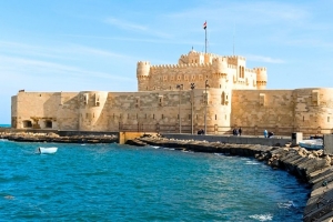
There are a number of forts in Egypt. The most famous of these is the Citadel in Cairo, but also notable is Fort Qaitbey in Alexandria, built on the location of the legendary Pharos Lighthouse. Probably the least known of the major forts is located on Pharaoh's Island in the Gulf of Aqba. This fortress would undoubtedly draw much larger crowds of tourists were it located in a more mainstream tourist destination, but tourists who make an effort to visit the fort will usually have the island mostly to themselves.
Pharaoh's Island, sometimes called Coral Island, or Geziret Faraoun, is the location of a Crusader fortress originally built by Baldwin I, the King of Jerusalem. From the top of the fortress, one can see four countries, including Egypt, Israel, Jordan and Saudi Arabia. Work apparently began on the fortress around 1116 AD. Baldwin built the Fortress for three reasons: First it was in the center of a huge trade route between the far East and Europe, second it was easily defendable, being out of range of land based catapults and was on high ground and third it was in the narrowest section of the Gulf of Aqaba.
At various times while in Crusader hands, it was used to collect taxes on Arab merchants, and sometimes to attack Arab shipping, while at the same time protecting pilgrims traveling between Jerusalem and St. Catherine's Monastery. The fortification was, however, captured by Salah ad-Din in about 1170. He expanded the fortress considerably and that it was possibly not abandoned until the 13th century and the Mamelukes and Ottomans probably further enhanced it.
The fortress, which is completely renovated, has many small rooms some with arched doorways and other without. These rooms included sleeping quarters for the troops, bath houses and kitchens with huge ovens . There are towers to house carrier pigeons, which were used for relaying messages in the Middle Ages and circular towers for archers.
Little else of the Fortress history is known. Obviously at least one important battle took place there, when Salah ad-Din took the Fortress from the Crusaders, but beyond that we really here of no major battles involving the fort.
Dakhla Oasis
Dakhla
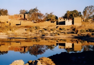
The Dakhla Oasis lies to the northwest of Kharga and is also about 310 km to the southeast of Farafra. This oasis consists of 14 settlements and has a population of about 70,000 people. Dakhla is the farthest oasis out of Cairo and is considered one of Egypt's most beautiful oases.
Dakhla sits in a depression surrounded by pink cliffs. There are about 30,000 acres of cultivated land. Most of its 70,000 or so residents are farmers who constantly fight the battle of the dunes that threaten their fields and orchards. The fields and gardens are filled mostly with mulberry trees, date palms, figs and other citrus fruits. Dakhla has retained most of its culture and charm even though it has increased in size by about double and government funding and technical training has revitalized the economy. Dakhla is the only place in Egypt where new water wheels which are driven by buffaloes are constructed. They are made of palm timber and clay jars and are called saqiyas. The oasis is connected to Kharga by a 120 mile (200 km) road that has buses running daily.
Research has found that the Oasis has been inhabited since prehistoric times, and that there was once a huge lake here. There are neolithic rock paintings that indicate that the lake was frequented by elephants, buffaloes and ostriches. As the lake dried up, the inhabitants migrated to the Nile valley and were probably some of its first settlers.
Dakhla Oasis is dominated on its northern horizon by a wall of rose-Colored rock. Fertile cultivated areas growing rice, peanuts and fruit are dotted between sand dunes along the roads from Farafra and Kharga in this area of outstanding natural beauty. The capital, Mut, named after the ancient goddess of the Theban Triad, houses the Museum of the Inheritance, a traditional house, with an intricate wooden combination lock. Rooms, with sculpted clay figures, are arranged to show different aspects of Dakhlan culture and family life. Mut is probably the most "tourist friendly" village in the Dakhla Oasis and does have some accommodations and amenities in that regard, including a number of hot sulphur pools. It has winding streets around old mud-brick houses, and there is an old citadel which is the remains of the old town. There is also a medieval Islamic cemetery on the outskirts of the village.
Al-Kasr, about 35 km. from Mut, was originally a Roman settlement which later became the medieval capital of Dakhla. The old town is a labyrinth of mud-walled alleys narrowly separating houses with elaborately- carved wooden lintels. It is little changed from medieval times. With a population of around 700, the town was built from the it's Roman ruins and has narrow covered streets. There are 54 lintels, some dating from the Ottoman and Mamluk era which adorn the old houses, one of which dates to about 924 AD.
There is also an Ayyubid mosque. It has a three-story mud-brick minaret, 21 meters high, and wooden lintels decorated with inscriptions from the Koran at the entrances. The local madrassa has been renovated, along with an old house which are open to tourists. Climb to the rooftop of the 10th century madrassa (school) for wonderful views of the surrounding area. Bir al-Gabel, a palm-fringed salt lake where you can camp and picnic, is on the road back to Mut.
Other local sites of interest include a pottery factory and an old corn mill. Mud bricks are still made in an ancient manner and there is a foundry where men still work mettle using bellows flamed fires.
Other day trips from Mut could include the 1st-century al-Muzawaka tombs and Deir al Hugar.
Al Muzawaka tombs are located 35 km away, they date back to the Pharaonic period. The most important are the rock hewn tombs of Pelusis and Petosiris. While the tombs are decorated in traditional Egyptian fashion, Petosiris is dressed as a Greek, and there is a bull on the ceiling from the Persian Mithras cult.
Deir El hagar (Monastery of the Rock) a temple which was originally dedicated to Amun and his wife Mut and has inscriptions representing religious life. It was later rebuilt by the Romans and it is one of the few Roman ruins in the area. It has been damaged by an earthquake but is said to have been recently restored. It was built during the rule of Nero (45-68 AD).
After exploring the temple, bathe in the hot sulphur spring nearby.Visit Bashendi to see Roman tombs and a factory where carpets are still woven with scenes of Dakhlan life. Bashendi is a village of Pharaonic design located about 40 km. east of Mut. It hosts an lslamic cemetery as well as Roman tombs, the most significant being the Tomb of Kitnes.
At nearby Balat village, a trading post with ancient Nubia, archeologàts are still uncovering dozens of 6th dynasty mastabas. Balat is a small village about 22 miles east of Mut in the Dakhla Oasis and was an important Old Kingdom town. Nearby is the Al-Adaba tombs and Ain Asil. Most notable are the five mastabas, which were discovered during a sandstorm. The best of these is that of governor Medunefer who served during the rule of Pepi II, where funeral artifacts, including gold jewelry was found. The village of Balat itself is picturesque and little changed from medieval times.
Cairo
Cairo
Cairo & Giza
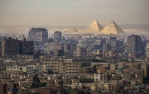
Cairo is the capital of Egypt and the largest Egyptian cities in Africa in terms of area and population. A cosmopolitan city that blends charm of the east with a Mediterranean flavor which accommodates 26% of Egyptian population. Cairo, the “city of the thousand spires”, has a wealth of monuments, mosques, tombs, churches, forts, palaces, and hotels representing over fifty centuries of civilization.
It is a melting pot where antiquities of pharaonic dynasties, Greco Roman civilization, Christian and Islamic landmarks co-exists. A dynastic city proud of its warm and friendly people known for their traditional hospitality.
What mainly attracts the visitor in Cairo is that vital blend of a majestic past and a glorious present at top of the Mokattam hills extending on the eastern bank of the Nile, where rises the Citadel of Salah El Din El Ayoubi, towering and impressive. On the western bank of the Nile and on top of Giza plateau rise the colossal pyramids and the mysterious Sphinx, the greatest tribute to Pharaonic art and thought and the vast necropolis of Memphis and Sakkara.
Between the Pyramids and the Citadel, there is modern Cairo with its network of roads, squares, gardens, clubs, amusement parks, luxurious hotels, skyscrapers and Cairo Tower rising 187 meters high.
One of the impressive places in Cairo is the Egyptian Museum, the largest of Egyptian antiquities museums all over the world.
In the heart of Cairo, the eternal River Nile flows gently from south to north. A Cairo visitor cannot miss sailing in a Nile felucca at sunset.
Cairo invites you to come and enjoy its beautiful all-year weather and visits the immortal monuments and relics, especially the ancient's pyramids in Giza.
Baharia Oasis
Bahariya
Set in a depression covering over 2000 sq. km., Bahariya Oasis is surrounded by black hills made up of ferruginous quartzite and dolorite. Most of the villages and cultivated land can be viewed from the top of the 50-meter-high Jebel al-Mi'ysrah, together with the massive dunes which threaten to engulf some of the older settlements.
The Oasis was a major agricultural center during the Pharaonic era, and has been famous for its wine as far back as the Middle Kingdom. During the fourth century, the absence of Roman rule and violent tribes in the area caused a decline as some of the oasis was reclaimed by the sand.
Wildlife is plentiful, especially birds such as wheatears; crops (which only cover a small percentage of the total area) include dates, olives, apricots, rice and corn.
There are a number of springs in the area, some very hot, such as Bir ar-Ramla but probably the best is Bir al-Ghaba, about 10 miles north east of Bawiti. There is also Bir al-Mattar, a cold springs which poors into a concrete pool
Otherwise near the Oasis is the Black and White deserts, though traveling to the White desert seems not practical from the oasis. The Black Desert was formed through wind erosion as the nearby volcanic mountains were spewed over the desert floor.
Finally, there are the ruins of a 17th Dynasty temple and settlement, and nearby tombs where birds were buried.
Bawiti, Bahareya’s capital , is by far the largest village in the Bahariya Oasis with some 30,000 inhabitants. The town center is modern, while outside the center are mud-brick houses. Recently, the town has received considerable press due to the find of a huge (possibly the largest) necropolis of mommies from the Greco-Roman era.
Over time, the Bahariya Oasis has had a number of different names. It has been called the Northern Oasis, the Little Oasis, Zeszes, Oassis Parva and the especially during the Christian era, the Oasis of al-Bahnasa, along with various other names.
Remains of stone tools found in the Bahariya oasis evidence the existence of settlements in the area as early as the Paleolithic Period.
Is seems that the Bahariya Oasis was originally inhabited by a mix of people from the Nile Valley and Bedouins from Libya. At that time, evidence suggests that the Oasis was much larger than it is now, but no settlements dating to the Predynastic, Early Dynastic or Old Kingdom have thus far been unearthed.
By the Middle Kingdom, Bahariya was known as Zeszes, and definitely fell under the control of the Egyptian kings, though only a single scarab (inscribed with the name of Senusret) from that period has been found in Bahariya. Yet, documentary evidence provides that both Amenemhet and Senusret II began to pay considerable attention to the Oasis, probably to deflect regular attacks from the Libyans. At that time, there must have been large agricultural estates, large houses for the landowners, and even military garrisons to keep marauders at bay. Agriculture was, as it is now, of major importance to this community, and wine, as well as other goods of the Oasis, made their way from here to the Nile Valley by donkey caravans along two different routes.
However, during the 15th Dynasty, when Egypt was under the rule of the Hyksos kings from Palestine, there was a lapse in trade with the Oasis, presumably because the trade routes were unsafe. At that time, we find only one text that refers to the Oasis, when King Kamose refers to it as DjesDjes, the word for the region's famous wine.
Under King Tuthmosis III, many improvements were made in the Oasis, including new water wells. His reign marked an increase in the local population. At this time, the Oasis was under the control of Thinis (Abydos), to which they paid tribute. We find visual evidence of this in the private tomb of Rekhmire, who was Tuthmosis III's vizier. One scene portrays the people of the Oasis, wearing striped kilts, presenting gifts of mats, hides and wine. However, the Oasis apparently had at least a governor who was a native of Bahariya, for the oldest tomb so far discovered in the Oasis is that of Amenhotep Huy, where his title is given as "Governor of the Northern Oasis". The tomb is dated to the end of the 18th Dynasty or the beginning of the 19th. By the 19th Dynasty of Egypt's New Kingdom, the Bahariya Oasis became even more important because of its mineral abundance. Even today, the mining of iron ore continues to be a vital industry. Even Ramesses II, in the Temple of Amun at Luxor, refers to the Bahariya as a place of mining. Of course agricultural products continued to be important in the Oasis, including dates, grapes, figs, livestock and pigeons (for food).
During the 25th and 26th dynasties Bahariya Oasis flourished as an important agricultural and trade center. Specifically, by the 26th Dynasty, Bahariya prospered with its own governors who were natives of the oasis. They apparently continued to report to Abydos, where there apparently remained a governor over all of the Oasis. By the time of Ahmose II (570-526 BC), the importance of the Bahariya Oasis was fully understood. He sent troops into the Western Desert to defend Egyptian interests against the Greeks and Libyans, and acted vigilantly to protect this Oasis. To honor him, two temples were erected, along with a number of chapels near Ain el-Muftella (near El Bawiti). These temples were embellished even into Egypt's Persian period.
During the Persian period that followed a series of takeovers by the Nubians and Assyrians, a strong military presence and garrison were established in the Bahariya Oasis. They may have been responsible for some of the antiquities that have been attributed to the Romans. However, they could not stop the conquest of Egypt by Alexander the Great, once he decided to make Egypt his own.
It is very possible that Alexandria the Great traveled through the Bahariya Oasis on his way to the Oracle of Amun at Siwa. At first, Egypt was a organized under a centrally controlled government headed by Alexander's commander, Ptolemy, and the Bahariya Oasis immediately began to prosper. Not only were trade routes reestablished, but the Greeks used the Oasis to establish control over the rest of the Western Desert. In fact, they set up an extensive, permanent military garrison to protect the trade routes. During the Roman and Greek Periods, we seem to know more about the Bahariya Oasis than from any other period of time. It was during the Greek period that the cemetery known as the Valley of the Golden Mummies came into existence.
During the Greek period, we know that Thoth was worshiped in the Oasis, particularly in his Ibis form, while Hathor is referred to as the "Lady of Bahariya Oasis". Khonsu, the moon god and Amun were both called "Lords of the Bahariya Oasis", though Amun was dominant.
The Romans made many improvements within the Oasis, building an impressive series of aqueducts and wells, several of which are still used in Bawiti and Izza today. This oasis was important to the Romans as a breadbasket, and we find many tombs dug into the sides of the Bahariya mountains during Roman times. There were public works projects, new agricultural communities were formed, roads were cut, and thousands of mud-brick buildings were constructed.
During the Christian period, when Egypt continued under Roman rule, Bahariya was known as the Oasis of al-Bahnasa. There are many churches in the area, including a church named after Saint Bartholomew. There was also a monastery that stood in Bawiti called Dar al-Abras, the Lepers' Refuge, there had been crosses engraved on the walls, paintings, and contained many old writings. At that time the Christians called Bahariya Mari Girgis (St. George).
Bahariya was known as the Northern Oasis, or sometimes as Waha al-Khas during the early Islamic period. How exactly the religious pecking order of the Bahariya was made up during the Christian and Islamic periods is unclear, but it is evident that the Oasis had a considerable Christian community until the 16th or 17th century. Amir Ibn el-As, the commander of the Arab army that conquered Egypt, sent troops to ensure political stability within the Western Desert. During this period, the oasis suffered considerably, as did most places in the Western Oasis; sand dunes covered cultivated land, and the trade in wine was abandoned due to the edicts of Islam. Taxes were now levied against dates and olive oil. Much of this period is relatively unknown to us, but the Fatimids, who had affiliations in Libya, may have crossed the desert in the conquest of Egypt at Bahariya.
Muhammad Ali, often sited as the founder of modern Egypt, made claim to the Bahariya Oasis, as early as 1813 and travelers began to visit the area.
Today, Bahariya's history continues, more detailed than before. Besides archaeologists who seem to have an ever increasing interest in the Oasis, a genealogical history is also kept by several Sheikhs. They not only record births, and deaths, but also surprising events, such as an encounter with a jinn or other supernatural creatures. Three books are kept, including one in Bawiti, another in Mandisha and a third in the area of El Haiz.
Owing to a marked drop in agricultural land bought about by the declining water table under Bahariya, the Oasis suffered a sharp decline in population during the 1950s. It reached a level of no more than about 6,000 residents, but by 1986, the population increased to 20,000 and today there are about 27,000 people living in Bahariya. This is mostly due to a new paved road system established in 1973 over the old caravan routes, allowing a better lifestyle as well as an increase in tourism. Yet the Bahariya Oasis, though the closest to Cairo in kilometers, remains the most distant in time. It has been slow to move into the modern world, a facet that is changing, but for at least the moment, this Oasis offers the visitor a step back in time into medieval streets and a rare, ancient culture.
Aswan
Aswan
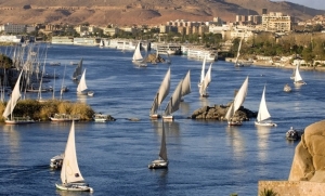
Situated on the Eastern bank of the Nile, 899 km south of Cairo , Aswan links Egypt with the sister country of Sudan. it is the gate of the African Continent and as such is an important commercial centre .Aswan is considered the most beautiful winter resort not only in Egypt but also on the whole world as it is distinguished by its fascinating nature and serenity far from the bustle of cities and its warm weather witch is characterized by dryness and sunshine throughout the year.
You can spend a pleasant time wandering along the Nile Cornish where the sandy tourmaline desert merges with the granite rocks around aquamarine isles covered with palm trees and plants. You can also take a felucca on the Nile at sunset. Or a tour in the market which abounds in handicrafts local products, spices and Perfumes
Aswan is the base for excursions to temples of Philae and Kalabsha, the high dam, the unfinished obelisk and the Nubian Museum as well as the Elephantine, Kitchener islands.
The main attractions on the west bank of the river are the Mausoleum of Akha Khan and the desert monastery of St.Simon.
It can also serve for day-trips to Darow Camel Market, Komombo, Edfu and Esna and above them all the excursion to Abu Simbel either by road or by flight or even with Nile Cruise which sail in Lake Nasser until Abu Simbel.
Alexandria
Alexandria
Alexandria is not only the largest port and second city of Egypt but also the greatest summer resort in the Middle East. It is located in the Mediterranean Sea North West of Delta, 225 km from Cairo by agricultural road and 221 km by desert.
It is internationally known as the bride of the Mediterranean with beaches extending a long the Mediterranean some 30 km.
Named after Alexander the Great it was built at his orders on the site of a small old fishing village called Rhakotis, in 322 BC to be the capital of his reign in Egypt, a port near to his country and a Greek cultural center.
Since its foundation Alexandria remained for many centuries a center of cultural radiation in the whole world. It occupied a remarkable place in the history of mankind .therefore most of the touristic places in Alexandria date to the Ptolemaic and the Greco roman era like the Catacombs of Kom Shuqqafa, the Pompey's Pillar , the Greco roman museum and the roman Amphitheatre
The Arabs occupied Alexandria and al-Fustat which later became Cairo, the capital of Egypt. Nevertheless, Alexandria continued to flourish as a trading center, principally for textiles and luxury goods, as Arab influence expanded westward through North Africa and then into Europe. The city also was important as a naval base, especially under the Fatimids and the Mamluks, but already it was contracting in size in line with its new, more modest status.
Alexandria survived the early Crusades relatively unscathed, and the city came into its own again with the development of the East-West spice trade, which Egypt monopolized. The loss of this trade--which came about after the discovery of the sea route to India in 1498 and the Turkish conquest of Egypt in 1517--was the final blow to the city's fortunes. During the Ottoman Empire Alexandria was a free port open to all men and ideas. Under Turkish rule the canal linking Alexandria to the Rosetta branch of the Nile was allowed to silt up, strangling the city's commercial lifeline. Alexandria has been reduced to a small fishing village when Napoleon invaded Egypt in 1798.
After the 1952 coup in Egypt, most of Alexandria's foreign population left but the city still remains a thriving commercial community and an important industrial center
Alexandria was famed for its lighthouse, one of the six vanished wonders of the world. Legend speaks of how a mysterious mirror could reflect the light tens of kilometers away. Legend says the mirror was also used to detect and burn enemy ships before they could reach the shore.
one of the greatest culture and Scientific centers specialized in the affairs , civilization , literature , sciences and arts is the library of Alexandria which attracts scholars from all over the world.
Today Alexandria is considered the second capital of Egypt. It is distinguished by its strategic location, moderate climate and its beautifully fine sandy beaches which cover a large area between Agamy in the west and Abu Qeir in the east, which made it worthy of its well merited title “Pearl of the Mediterranean”
Abu Simbel
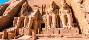
Abu Simbel
Situated 280 km south of Aswan, the two temples of Abu Simbel are the most magnificent temples in the world.
The first temple was built by the mighty Pharaoh Ramses II ( 19th dynasty) the most famous pharaoh among the Ancient Egypt History with building and restoration temples .the other for his wife Queen Nefertari
In 1964 they were threatened by submersion in Lake Nasser due to the construction of the High Dam.
The Egyptian Government secured the support of UNESCO for the removal and reconstruction of the two temples.
The temples were dismantled and raised over 60 meters up the sandstone cliff where they had been built more than 3,000 years before.
The project completed by an international team of 3000 specialists, cut the Temple into 2000 pieces, carved the entire Temple out of the cliff and reconstructed both cliff and Temple nearby.
The project took $40 million to complete; one of the most ambitious relocation projects in history.
Women in Egypt

Women’s in Egypt
Unlike many other traditional societies, Egyptian women enjoy full equality with men, although they have some different cultural roles. They have the same financial rights and professional respects accorded to them and are vastly influential in the home and the workplace. In Egypt the variations between individuals' legitimate rights depend much more on contrasts in social class than on gender. Lawful and monetary rights are similar for both men and women in Egypt.
Egypt treats its women better than any other country in the old world. Ancient Egyptian culture already offered women the best chances in comparative Mediterranean societies in terms of their financial, legal and social positions and that trend continues today.
Egyptian women can own property and, if married, she can claim joint property with her spouse. Property that a woman buys on her own is up to her to sell or do with what she wants.
Ancient Egypt had a wide range of possibilities open to women depending on their social class. Women in the lower classes did not only work inside the home taking care of the family and its needs, they also worked outside the home tending domesticated animals and working in the fields, especially at harvest. Women worked in many occupations, for example they were talented weavers, artists, stewards, writers, artists, brewers, caretakers and cooks. There were also many positions accessible for learned women in ancient times, for example as priestesses, temple overseers, and business managers. In a few cases women even became judges, managers, governors, specialists, and pharaohs!
While a lady was respected and highly regarded in ancient society she was expected to listen to her husband and his wishes, which still continues today in much of Egyptian tradition and contemporary Muslim belief. The woman was in charge of the family and highly respected for that. She looked after the kids, arranged nourishment, cleaned and kept things in order. In well-off and white collar families, servants did a significant part of the work around the house, while the women, especially the affluent, were women of relaxation and leisure. Women of the family were always regarded as highly competent and strong and revered for their ability to keep order in the home and even in the afterlife.
Egyptian women have always set exceptional importance on individual appearance and cleanliness. Since ancient times a woman's status has been characterized by her dress, with high class women wearing beautiful garments, extensive cosmetics, and adornments to separate themselves from the lower classes who dressed in more basic ways. Intricate head decorations were especially important in implying a lady's social standing in ancient Egypt. Higher class women had the opportunity to be educated while lower class usually did not have this opportunity
What to Wear in Egypt

What to Wear on Holiday in Egypt,
While on holiday in Egypt, you can dress as you dress home. but if you want to show respect to the Egyptian local custom, you will enjoy greater interaction with the people, they will have more respect for you and it will save you from some unwanted attentions.
Egypt, being a predominantly Muslim country, is naturally conservative (not like the Gulf States or Saudi Arabia) but the average people are careful in what they wear. The dress code in Egypt for women is considered conservative by western standards and it is respectful to obey this code.
Basic clothes could include loose linen/cotton trousers or a below knee skirt and sleeved blouse. (If you’re planning to ride a camel, a skirt is not a good idea.)
Tight clothes and low necks are to be avoided. Also avoid transparent blouses or pants as they are also not welcomed and will draw attention and even comments, especially from young men.
What to Wear on Holiday in Egypt
- Long flowing skirts & maxi dresses
- Long sleeve or 3/4 length shirts in gauzy fabrics
- Tops that cover the collar bones and arms
- Loose linen pants
- Bring a shawl or scarf to cover up
What Not To Wear On Holiday in Egypt
Shorts, Visible undergarments, Low-cut tops (bring a scarf or shawl to cover up)
For men it is not really an issue – normal trousers and shirt or T-shirt are fine — but in Cairo it would not be acceptable to wear short shorts or a tank tops/sleeveless tops. In the resorts like Sharm El Sheik, Hurghada, Marsa alam, Sinai, etc. — shorts are fine and it is very open and flexible.
Going out to dinner, especially in a nice restaurant, it is advisable to wear smart clothes and having a shawl to cover bare shoulders, would be a good idea. On cruise boats, it is nice to have something smart to wear in the evening.
Comfortable, strong shoes are a must (that could be sneakers/ trainers or good leather shoes). Sandals can be worn, but you will suffer from dust /sand, in general, having closed shoes is the better option.
When Entering a Mosque: – It is better to observe the conservative dress code as above, when entering a mosque as a tourist and in some of the major mosques (Al-Azhar for example) women will be required to cover up and this is provided by the mosque.
Some mosques like Mohamed Ali and many others, just remove your shoes and walk in socks. Any Muslim entering a mosque for prayer will simply remove his/her shoes, so why should a tourist be different?
For other mosques ( i.e., Ibn Tulun) have canvas shoe covers (not easy to walk in), so it is possible to decline, but Ibn Tulun mosque is not in use for daily services, so it is not always very clean, and using the shoe covers can be good for the areas that have no carpets like the central court.
In winter it can get cold at night in Egypt. Often it is warmer in the street than it is inside buildings, so it is a good idea to bring a casual jacket or shawl. The buildings are designed to be cool and it is good to be aware of this. Here it’s very rare to have central heating or central air conditioning except in big hotels and other high class places.
Some tourists wear what they like (tank tops, sun dresses, short shorts, low necks, see- through blouses) – without any consideration for the local culture or customs. This can be done, of course, and the tourists then imagine that this is ok (and strongly recommend it to others). But, in fact, having done it without having comments made directly to them or encountering trouble, it still does not make it the right choice. They are oblivious to the very bad impression they have left behind.
The dress code is much more relaxed on a cruise boats than it is in town. Dress as though you were in a tourist hotel. Shorts, swimming costumes, bikinis are all fine, but have something handy to cover up for when the ship gets to a town.
On four and five-star ships it is normal to dress up slightly for the evening meal. Few people would go as far as a tie for men or a long dress for women, and some people may go in shorts, but smart casual is expected. Shirt and full length trousers for men, and a dress or trousers or skirt with blouse for women.
Shopping In Egypt
Shopping In Egypt
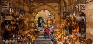
Egypt is a shopper's paradise - especially if you're interested in Egyptian-themed souvenirs and kitsch. However, there are also a number of high quality goods for sale, often at bargain prices. Some of the most popular purchases include:
Antiques (NB: not antiquities, the trade of which is rightly illegal in Egypt)
Carpets and rugs
Cotton goods and clothing Can be bought at Khan El Khalili for around 30-40 EGP. Better quality Egyptian cotton clothing can be bought at various chain stores including Mobaco Cottons and Concrete which have many branches throughout the country. The clothes are expensive for Egypt (about 180-200 LE for a shirt) but cheap by Western standards given the quality.
Inlaid goods, such as backgammon boards
Jewelers Cartouches make a great souvenir. These are metal plates shaped like an elongated oval and have engravings of your name in hieroglyphics
Leather goods Music Papyrus
Perfume - Perfumes can be bought at almost every souvenir shop. Make sure that you ask the salesman to prove to you that there is no alcohol mixed with the perfume. The standard rates should be in the range of 1-2 Egyptian Pounds / gm
Water-pipes (Sheeshas)
Spices - can be bought at colourful stalls in most Egyptian markets. Dried herbs and spices are generally of a higher quality than that available in Western supermarkets and are up to 4 or 5 times cheaper, though the final price will depend on
Bargaining and local conditions. When shopping in markets or dealing with street vendors, remember to haggle.
You will also find many western brands all around. There are many malls in Egypt, the most common being Citystars Mall, which is the largest entertainment center in the Middle East and Africa. You will find all the fast food restaurants you want such as McDonald’s, KFC, Hardees, Pizza Hut, etc. Clothing brands such as Morgan, Calvin Klein, Levi's, Facconable, Givenchy, Esprit, and more.
In Egypt, prices are often increased for foreigners, so if you see a price on a price tag, it may be wise to learn the local Eastern Arabic numerals:
Latin Numerals 0 1 2 3 4 5 6 7 8 9
Eastern Arabic numerals
Like Latin Numerals, they are written from left to right. For example, the number 15 would be written as
Shopping in Egypt ranges goods and commodities that represent souvenirs of Egypt's ancient as well as modern things. These include items such as small pyramids, obelisks, and souvenir statues which can be bought at more touristic areas such as Khan El Khalili and Islamic Cairo.
You can also do general shopping in Cairo for clothing items and other goods such as in the modern shopping malls of City Stars, City Center, Arcadia Mall, or Nile City (all of which contain some of the most famous designer brands of the world, including Guess, Calvin Klein, Armani, Hugo Boss, etc.